Agras T50 Near Urban Fields: A Consultant’s Case Study
Agras T50 Near Urban Fields: A Consultant’s Case Study on Precision, Drift Control, and Why Side-Angle Imaging Matters
META: A field-based Agras T50 case study for near-urban agriculture, covering spray drift control, RTK precision, swath planning, battery discipline, and how 3D side-angle imaging improves safer, cleaner operations.
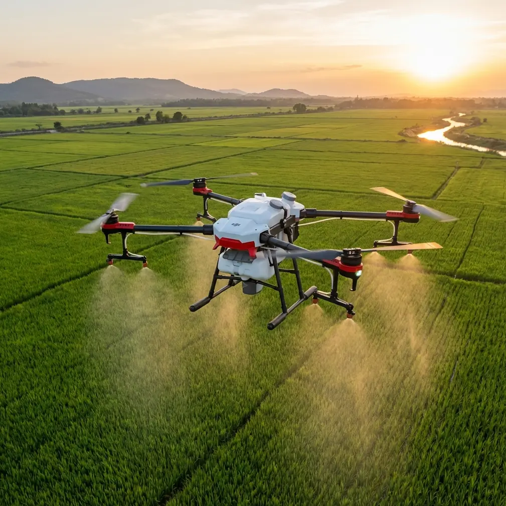
When people talk about the Agras T50, they usually jump straight to throughput. Acres per hour. Tank cycles. Route efficiency. Those metrics matter, but they are not the whole story when the field sits close to roads, buildings, greenhouses, utility lines, or residential edges.
That is where the T50 becomes more than a spraying platform. In near-urban agriculture, it has to function as a precision system. Every pass has consequences. Swath width affects overlap and off-target deposition. RTK fix stability shapes boundary confidence. Nozzle calibration determines whether the aircraft is delivering a controlled application or simply moving liquid through the air. And before any of that, imaging and site understanding decide whether the mission is even set up safely.
I was brought into one project involving fragmented fields on the edge of a built-up area. The grower’s first concern was predictable enough: keep coverage uniform. The second concern was the one that actually drove the workflow design: avoid drift toward adjacent structures and narrow public corridors while still maintaining efficient treatment windows.
That is a different operating mindset from broadacre flying in open space.
The overlooked lesson from 3D mapping: top-down views are not enough
A useful reference point comes from a training document on UAV-based heritage mapping. At first glance, that sounds far removed from crop work with an Agras T50. It is not. The document makes one operational point that every serious drone operator should pay attention to: conventional aerial image sets often capture only the top-side characteristics of a subject, while missing detailed side contours and textures. That gap makes full model reconstruction weaker.
In the training example, the operator flies around the sides of a box-shaped structure at different heights, either from lower to higher angles or from higher to lower angles, circling the object to collect side-facing imagery. The aircraft also uses TOF distance sensing to recognize corners and execute right-angle turns automatically.
Why does that matter to an Agras T50 operator filming or documenting fields near urban edges?
Because top-down field awareness is often incomplete in exactly the places where mistakes become expensive.
If your planning only relies on a simple overhead map, you may miss:
- wall faces that create wind turbulence,
- fence lines that alter rotor wash behavior close to the boundary,
- orchard edges or shelterbelts that trap or redirect droplets,
- building setbacks that compress turning space,
- utility obstacles that are obvious from the side but less obvious from above.
The old mapping lesson is simple: side information changes the quality of the model. In practical T50 work, that same principle changes the quality of the mission.
On this project, we did not treat pre-operation filming as marketing footage. We used it as operational reconnaissance. Oblique views and perimeter fly-throughs gave us the missing geometry that overhead screenshots could not. The result was a cleaner treatment plan with fewer surprises at the edge zones.
Why this matters specifically for urban-adjacent spraying
Near urban blocks, spray drift is not an abstract agronomy topic. It is the operating constraint that shapes everything else. You can have excellent application volume targets and still create a poor outcome if wind interaction, edge turbulence, or route design pushes material beyond the intended boundary.
The T50 is often discussed in terms of capacity and heavy-duty field work, but in these mixed environments, the stronger value is controllability. You need a predictable aircraft with stable path execution and repeatable application behavior.
That is where centimeter-level route confidence becomes significant. If the RTK fix rate stays healthy, the aircraft’s path repeatability improves, especially when managing narrow offsets from no-spray buffers, roads, drainage strips, or planted border rows. Precision is not just about neat maps. It directly affects how much confidence you have in each edge pass.
I have seen operators obsess over headline speed while ignoring boundary geometry. That is backwards in urban-edge agriculture. When a field narrows near development, swath width and turn behavior become more critical than raw output. A wider pass can be efficient in open sections, but if the same pattern forces awkward overlap near the boundary, you may lose the benefit in both chemical efficiency and drift control.
The best operators treat the field as a set of zones, not a single block.
A practical case: filming fields before spraying with the Agras T50
In this case, the site had three problem characteristics:
- irregular field edges,
- built structures along one side,
- wind exposure changing across the block.
Before the first treatment run, we captured structured footage designed to answer operational questions, not aesthetic ones. We wanted visual confirmation of:
- how the crop canopy transitioned near hard boundaries,
- where tree lines or walls would likely disrupt airflow,
- whether turning areas gave adequate space for clean exits and entries,
- where visual line-of-sight references were weak,
- and whether edge buffers needed to be widened in specific segments.
This is where the 3D-mapping reference becomes unexpectedly valuable again. The heritage survey example describes circling a square-sided subject at multiple heights to improve side-detail capture. That same method, adapted for a field perimeter, is one of the fastest ways to understand the actual vertical environment around an application zone.
A top-down map tells you where things are. A side-angle pass tells you how those things behave.
That distinction matters when you are assessing spray drift risk.
TOF logic and why corner awareness is more than a tech detail
The training reference also mentions the aircraft using TOF measurement to determine when it has reached a building corner, followed by an automatic right-angle turn. That sounds like a classroom exercise, but the concept has real operational significance.
In near-urban field work, corners are where route quality often degrades. Operators either cut them too tightly, creating uneven coverage, or swing too wide, increasing off-target exposure and wasting time. Any sensor-driven awareness that improves spatial handling around corners and edge transitions contributes to safer, cleaner flight behavior.
The point is not that an Agras T50 should be flown like a heritage mapping drone. The point is that structured sensing around edge geometry is valuable. It helps reduce the mismatch between planned paths and real-world conditions.
When fields are boxed in by non-crop features, corner discipline becomes a serious part of application quality.
Nozzle calibration is where credibility begins
Urban-adjacent spraying leaves little room for casual setup. If your nozzle calibration is off, every later discussion about route intelligence or RTK accuracy starts to lose weight. Uniform delivery begins on the ground.
My standard advice is boring but non-negotiable: verify nozzle condition, confirm flow consistency, and re-check output after any hardware change or unusually dusty operating day. In edge-sensitive work, a minor deviation in droplet behavior can have outsized consequences.
The Agras T50 gives operators a serious platform, but a serious platform does not rescue sloppy calibration. If you are working near structures or pedestrian corridors, calibration is part of risk management, not just application efficiency.
This is also the point where many teams underuse imaging. Filming the aircraft during a controlled test pass can reveal asymmetry in visible spray behavior, unstable height holding near boundaries, or pattern distortion under crosswind influence. Used properly, footage is diagnostic evidence.
The battery tip I give every T50 crew
Here is the field habit that saves more trouble than most people expect: do not rotate batteries purely by convenience. Rotate them by thermal and mission logic.
On paper, battery swaps are simple. In the field, especially on warmer days near reflective surfaces like roads, roofs, or light-colored structures, pack temperature and recovery time can quietly shape aircraft performance and crew decision-making. A battery that goes back into service too quickly may still be carrying heat stress from the previous sortie.
My rule is straightforward:
- tag packs by sequence,
- track which packs handled the heaviest edge work,
- and give those packs enough cooling time before assigning them to another precision-critical mission segment.
Why edge work specifically? Because that is where pilots tend to make more micro-corrections, hover transitions, and conservative turn setups. Those flight patterns are not the same as long, clean runs over open space. They can create a different workload profile than many crews assume.
I have seen teams maintain excellent application consistency simply by becoming disciplined about battery rotation timing. It is not glamorous. It works.
RTK fix rate and centimeter precision: useful only if the plan respects the site
Centimeter precision gets mentioned so often in drone agriculture that it can start to sound like decoration. In reality, its value depends on whether the mission design makes that precision meaningful.
If your field plan ignores turbulence zones near walls, narrow access lanes, or irregular setbacks, then highly accurate positioning only helps you repeat a flawed route. Precision is powerful when paired with site-aware planning.
That is why I push for pre-mission perimeter filming and oblique visual review in urban-adjacent blocks. The goal is to connect:
- RTK-based path reliability,
- swath width decisions,
- height management,
- and drift-sensitive edge behavior.
When those pieces line up, the T50 starts delivering what operators actually need: repeatability without guesswork.
IPX6K matters less in theory than in maintenance behavior
A lot of spec-sheet reading leads operators to become comfortable too quickly with environmental resilience claims. Yes, an IPX6K-level protection profile is reassuring in commercial agricultural work. It means the platform is built for demanding conditions. But it should not be treated as permission to relax maintenance habits.
Near urban environments often introduce a different contamination mix than remote blocks: road dust, fine debris, residue accumulation near infrastructure, and repeated stop-start cycles. A robust airframe still benefits from disciplined cleaning and inspection, especially around spray system components and sensors.
Durability helps the machine survive the job. Maintenance helps it stay trustworthy.
What the Agras T50 does well in this scenario
For fields near urban areas, the T50’s real strength is not brute capacity alone. It is the ability to combine:
- stable precision routing,
- controlled application,
- efficient zone-based field segmentation,
- and data-informed planning.
And that planning piece is where many operations are still leaving value on the table.
The surprising insight from the heritage-mapping material is that side detail matters because reality is not flat. Aerial operators know this instinctively, yet many still plan agricultural missions as though overhead visibility tells the full story. It does not. Side geometry, corner behavior, and vertical obstacles shape how safe and accurate a field operation will be.
That reference also points to something else worth remembering: if image sets carry coordinate information, the resulting model can preserve accurate geographic positioning. For commercial ag teams, that means better traceability when documenting sensitive edge conditions, recording pre-treatment site context, or comparing changes over time. Documentation is not bureaucracy when the field borders people and property. It is protection.
If you are refining an Agras T50 workflow for dense or mixed-use surroundings and want to compare route logic, drift mitigation choices, or filming setup ideas, you can share your field scenario here: message Marcus directly.
The bigger operational takeaway
The Agras T50 is often evaluated by what it can carry and how fast it can clear a block. Those are valid measures. But in urban-edge agriculture, the better question is this: how well does the entire operation hold together when space tightens, boundaries matter more, and every pass has to be defensible?
That is where disciplined crews separate themselves.
They calibrate nozzles carefully. They respect RTK quality without worshipping it. They choose swath logic based on field geometry, not habit. They film with purpose. They study side angles, not just top views. And they manage batteries as part of mission quality, not as an afterthought.
The T50 rewards that kind of thinking. Not with hype. With cleaner execution.
Ready for your own Agras T50? Contact our team for expert consultation.