Agras T50 for Mountain Fields: An Expert How-To for Stable
Agras T50 for Mountain Fields: An Expert How-To for Stable, Precise Work When Weather Turns
META: Expert how-to guide for using the DJI Agras T50 in mountain fields, with practical advice on spray drift, nozzle calibration, RTK fix stability, swath width, and mid-flight weather changes.
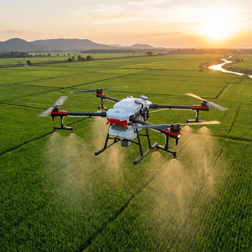
Mountain agriculture exposes every weak point in an aerial application workflow. Terrain breaks line of sight. Wind behaves differently on each slope. Moisture lips over ridgelines and settles in pockets. A drone that feels predictable over flat acreage can behave very differently when the field climbs, folds, and channels moving air. That is exactly why the Agras T50 deserves a more serious discussion than the usual feature recap.
I am approaching this as a field operations problem, not a brochure exercise. If your actual scenario is working around mountain fields—whether documenting conditions before treatment, mapping problem zones, or conducting precision spray runs—the T50’s value is tied to how well it holds position, preserves application consistency, and adapts when conditions change after takeoff. Those are the moments that determine whether a flight produces clean agronomic results or a messy compromise.
This guide focuses on how to use the Agras T50 effectively in mountain terrain, with special attention to spray drift, nozzle calibration, RTK fix rate, swath width management, weather shifts, and wet-environment durability. The drone is capable, but mountain work punishes lazy setup. Good outcomes come from disciplined procedure.
Start with the mountain, not the drone
Before discussing settings, define the operating environment correctly. “Mountain field” is not one condition. It usually combines four:
- uneven elevation changes across a short horizontal distance
- variable wind caused by ridges, tree edges, and valleys
- inconsistent crop height or canopy density
- reduced margin for positioning error near terraces, drainage lines, or steep margins
The Agras T50 becomes useful here because it can support high-precision, repeatable operations when the mission plan respects those constraints. In practice, centimeter precision matters far more on a mountain slope than on uniform flat ground. A small lateral deviation can shift droplets off target, widen overlap on one pass, and leave a gap on the next. On a steep field edge, that error compounds quickly.
If you are filming fields in the mountains as part of your decision process, do not think of video capture as separate from application planning. Use those early flights to identify wind corridors, canopy variability, and terrain breaks that will later affect route geometry and droplet placement. A mountain operation improves when imaging, scouting, and treatment planning are treated as one integrated workflow.
Step 1: Build your route around RTK stability
The first operational question is not tank capacity or speed. It is whether you can maintain a dependable RTK fix rate across the full field. In mountain terrain, satellite geometry can degrade near ridges, dense tree lines, or cut slopes. When that happens, the difference between acceptable and excellent positioning becomes visible in pass alignment.
The Agras T50 is most effective when you are actually exploiting centimeter precision rather than merely assuming it. In practical terms, that means checking where the fix holds, where it drops, and whether those weak zones intersect the treatment area. If a section of the field consistently compromises the RTK solution, treat it as a mission-planning problem, not a drone problem. Adjust your takeoff point, base station placement, or route orientation before you ever load material.
Why does this matter operationally?
Because mountain fields exaggerate the consequences of poor line tracking. A minor deviation on a flat broadacre parcel may only create slight overlap. On a terraced or sloped plot, the same deviation can push spray toward a drainage edge or leave a thin untreated strip exactly where disease pressure tends to build. A strong RTK fix rate is not a technical luxury. It is the basis for reproducible agronomic work.
My rule in upland terrain is simple: confirm positional confidence before optimizing productivity. Throughput can wait. Precision cannot.
Step 2: Set swath width for the field you have, not the field you wish you had
Operators often make their biggest mountain-field mistake here. They carry over a comfortable swath width from easier terrain and assume the T50’s stability will compensate. It will not. Swath width has to reflect topography, canopy shape, and local air behavior.
A broad swath may look efficient on paper, but mountain airflow is rarely uniform enough to support aggressive spacing across an entire slope. Crosswinds can accelerate around ridgelines. Cool air can settle in hollows. Vegetation along a contour can redirect the plume. The result is inconsistent deposition even when the route line itself looks clean.
A narrower, more conservative swath width often produces better real-world coverage in mountainous parcels because it reduces the penalty of drift and overlap errors. Yes, that can mean more passes. It can also mean fewer misses, less rework, and more confidence that material lands where it should.
This is where field filming helps again. If you capture the site first, look closely at tree gaps, terrace lips, cut banks, and exposed corners. Those are usually the sections where you should tighten your pass strategy. The T50 gives you the control to work precisely, but only if your swath width assumptions match local airflow.
Step 3: Calibrate nozzles like coverage quality depends on it—because it does
Nozzle calibration in mountain work is not a box-checking exercise. It is the bridge between machine precision and biological effect. A drone can fly an impeccable route and still underperform if the application output is mismatched to canopy structure, terrain exposure, or changing weather.
With the Agras T50, calibration should be treated as a dynamic task. Start with the crop, target, and canopy density. Then account for slope-related airflow. A denser canopy on a sheltered lower slope may hold droplets differently from a thinner, wind-exposed upper section. If you calibrate for one and ignore the other, your coverage consistency deteriorates fast.
Operationally, two things matter most:
- droplet behavior in moving air
- output consistency across the effective spray band
The calibration target is not simply “the system is working.” The target is “the system is producing the droplet pattern and delivery profile this field can actually hold.” That distinction is critical in mountain terrain.
When operators complain about uneven results, they often blame weather alone. Weather is part of it, certainly. But poor nozzle calibration magnifies every atmospheric problem. Fine droplets become more vulnerable to drift. Uneven output worsens edge variability. In a mountain field, those weaknesses show up immediately.
Step 4: Treat spray drift as the central risk, not a side note
Spray drift in mountain operations is not only about wind speed. It is about wind behavior. That is a harder problem.
A field on a slope may appear calm at launch and become unpredictable at crop height. A valley breeze can shift direction as the sun warms one side of the terrain. Air can roll over a ridge and descend in a way that is not obvious from the pilot position. This is why experienced operators monitor the field itself, not just the general forecast.
Here is the practical framework I recommend for the T50 in mountainous areas:
- fly conservative early passes and observe droplet behavior at the field edge
- watch exposed corners and upper-slope sections first
- reduce swath assumptions if lateral movement appears inconsistent
- pause rather than “push through” when air structure changes
The T50’s precision gives you a chance to maintain controlled coverage, but no aircraft overrides bad atmospheric judgment. If drift starts to widen, the correct move is often to suspend, reassess, and restart with adjusted spacing or timing.
That decision becomes even more important near sensitive borders, water channels, or mixed-crop edges. Mountain farms often compress several land-use types into a small area. Drift control is therefore not only a quality issue. It is a stewardship issue.
Step 5: When weather changes mid-flight, discipline matters more than speed
This is where the Agras T50 can separate a trained operator from an impatient one.
Imagine a familiar mountain scenario. The mission begins under stable conditions. Halfway through the treatment block, low cloud slides across the ridge, wind shifts from a gentle upslope pattern to a more erratic cross-slope flow, and humidity rises. The field no longer behaves like it did ten minutes earlier.
What should happen next?
Not bravado. Not blind continuity. You use the T50’s stability, positioning, and route control to transition safely into a revised decision. Depending on conditions, that can mean slowing the mission, tightening the effective treatment area, pausing to preserve application quality, or ending the sortie and relaunching later.
This is where the aircraft’s practical resilience matters. An airframe designed for demanding field conditions, including an IPX6K level of protection, is operationally meaningful in mountain agriculture because weather often shifts from dry dust to mist or splash conditions quickly. That rating does not mean you should ignore safety or fly irresponsibly in poor weather. It means the platform is better suited to the dirty, wet, variable reality of farm work than delicate systems that resent every change in environment.
The larger point is this: weather shifts expose whether your workflow is robust. The T50 can handle demanding field conditions, but the operator still has to make evidence-based calls. Good aerial application in the mountains is often defined by the flights you choose to pause.
If you need a field-by-field discussion about route adjustments or drift management, this quick Agras planning chat is a practical place to compare setup options.
Step 6: Use multispectral thinking even when the mission is operational
The T50 conversation often gets trapped in application mechanics alone. That is too narrow. Mountain fields reward operators who think diagnostically.
Even if your primary objective is treatment rather than data collection, multispectral logic still matters. Areas of stress, uneven vigor, water pooling, or nutrient variation can reshape how you plan your passes and calibrate delivery. A mountain parcel rarely behaves uniformly from top to bottom. Canopy density shifts. Solar exposure changes. Moisture retention changes. Disease risk changes.
The result is straightforward: a single-rate mindset often leaves efficiency on the table and precision unrealized.
You do not need to force every mission into a complicated analytics exercise. But you should absolutely use prior imaging and crop-variability evidence to decide where your route tolerance must tighten, where drift risk is higher, and where coverage needs special attention. In mountain work, the best application flights are usually informed by what the field has already shown you from above.
Step 7: Build a repeatable preflight routine for steep terrain
For the Agras T50, mountain consistency comes from routine more than intuition. My recommended sequence is plain and strict:
First, evaluate the field geometry from the launch area and from captured imagery. Look for slope breaks, terrace edges, tree funnels, and wet zones.
Second, verify RTK performance where the route actually runs, not only at the takeoff point. A strong lock at launch tells you very little about shadowed or obstructed sections.
Third, confirm nozzle calibration against the intended application conditions, including any expected change in airflow across elevation bands.
Fourth, set a realistic swath width based on local terrain behavior. If uncertain, start narrower.
Fifth, define weather abort thresholds before takeoff. That removes emotion from the decision when conditions shift mid-flight.
This routine sounds conservative. It is. That is the point. Mountain work punishes improvisation.
What makes the T50 genuinely useful here
The Agras T50 is not interesting because it is powerful in the abstract. It is interesting because specific technical qualities become operational advantages in difficult geography.
Two details stand out.
The first is centimeter precision enabled through strong positional discipline. In mountain fields, precise line keeping supports cleaner pass alignment, tighter edge control, and better repeatability on irregular terrain. That has direct consequences for treatment accuracy.
The second is the platform’s IPX6K durability profile. In upland agricultural work, where mist, splash, dust, and changing weather can arrive in the same work session, environmental resilience is not cosmetic. It supports reliability when conditions become less than ideal.
Add careful nozzle calibration, realistic swath width selection, and constant drift awareness, and the T50 becomes far more than a “big farm drone.” It becomes a tool for imposing order on a landscape that naturally resists uniformity.
That is the real standard for mountain-field operations. Not how fast the mission looks. How controlled the result remains when the field, the slope, and the weather stop cooperating.
Ready for your own Agras T50? Contact our team for expert consultation.