Agras T50 Coastal Site Filming Guide: How to Fly Smarter
Agras T50 Coastal Site Filming Guide: How to Fly Smarter When Weather Turns Mid-Flight
META: Expert Agras T50 how-to for coastal construction site operations, covering wind shifts, RTK fix rate, nozzle calibration, spray drift, swath width, and IPX6K durability.
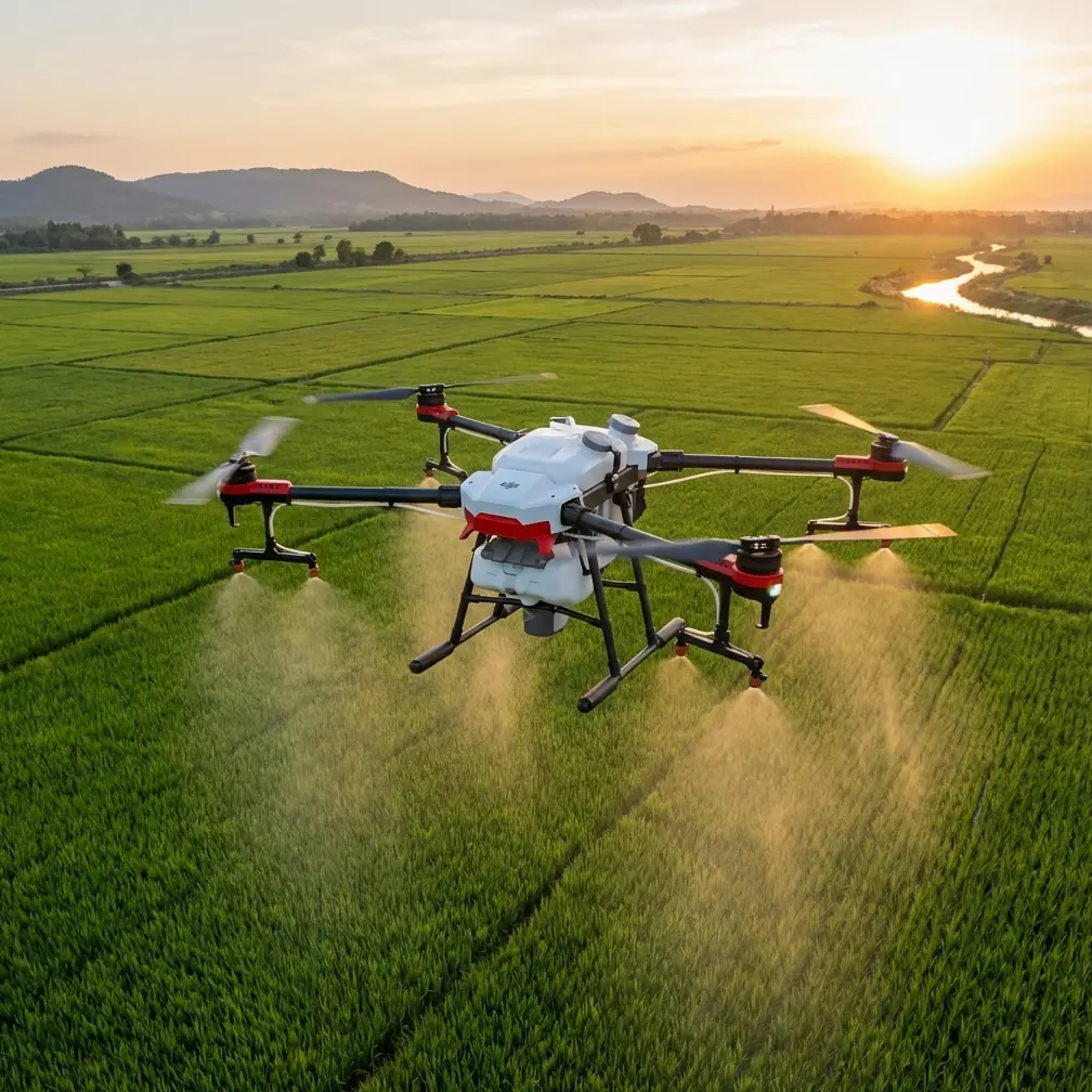
The DJI Agras T50 is usually discussed as an agricultural workhorse. That misses something useful. In the field, a platform built to hold line, maintain stable coverage, and keep operating through wet, dirty conditions can also teach a lot about disciplined low-altitude flight around exposed job sites. For coastal construction filming, that matters more than spec-sheet theater.
I’ve spent enough time around marine air, shifting gust fronts, and half-finished structures to know the real problem is not simply getting airborne. It is keeping the aircraft predictable after conditions stop behaving the way they did at takeoff. The Agras T50 is not a cinema drone, and pretending otherwise would be sloppy. But if your reader scenario is documenting a coastal construction site and learning from the T50’s strengths, there is real value in how this aircraft manages precision, environmental toughness, and repeatable path control.
This guide focuses on that operational reality. Not fantasy. Not brochure language. Just what actually matters when weather changes mid-flight and you still need clean, usable results.
Why the Agras T50 mindset fits coastal job sites
Coastal construction environments are hard on aircraft. Salt in the air, intermittent mist, reflective water, steel framing, unfinished concrete, and wide-open wind corridors all create a messy flight envelope. A drone that performs well there needs three things above all:
- positional discipline
- environmental resilience
- consistent response when airflow becomes uneven
The Agras T50 is relevant because it was built around precision application work, where swath width, overlap, droplet placement, and route consistency are not optional details. That engineering mentality transfers surprisingly well to site documentation. When you are trying to repeat passes along a seawall, track earthworks progression, or maintain a stable offset from a crane exclusion zone, centimeter precision is not a luxury. It is what separates a usable visual record from a collection of attractive but unreliable clips.
RTK support is one of the clearest examples. A high RTK fix rate gives the aircraft a much better chance of holding a repeatable track along long linear assets such as retaining walls, drainage channels, and shoreline stabilization features. On a coastal site, where the eye can be fooled by open space and moving water, reliable positioning keeps your passes consistent enough to compare footage from one week to the next. If your mission is progress documentation rather than cinematic improvisation, that consistency is operational gold.
Start with the wrong question and the flight goes wrong
Most people preparing for a site filming mission ask, “How windy is it?” That is too crude. The better question is, “How stable is the wind profile across the height and direction of my planned route?”
On the coast, a 10-minute window can contain three different conditions. At launch, the air can feel manageable at ground level. By the time the aircraft reaches the edge of a concrete frame or rises above a stockpile, it may encounter crossflow, uplift, or rotor-like turbulence rolling off structural edges. That is where heavy-duty platforms show their value. The Agras T50’s design philosophy favors stable task execution, and that stability mindset helps when the weather shifts after you are already committed to a pass.
I have seen this happen in a way every site operator recognizes. The flight begins under steady marine cloud with a mild onshore breeze. Halfway through the second leg, the cloud breaks, surface heating changes, and wind direction cants just enough to create a diagonal push across the route. On a lighter or less disciplined platform, the result is visible drift, inconsistent spacing, and abrupt corrections that show up in the footage. A machine engineered for precise route adherence responds with less drama. You still adjust. You just do not lose the mission.
That is the distinction professionals care about.
Pre-flight: set up like an operator, not a hobbyist
If you are using Agras T50 best practices as the framework for a coastal filming mission, your pre-flight planning should borrow from application logic.
First, map the route in segments rather than one continuous freeform orbit. Break the site into repeatable lanes based on geometry: shoreline edge, foundation footprint, material yard, vertical structure zone. This mirrors the way agricultural coverage planning relies on defined swath width rather than improvisation. In a filming context, that gives you cleaner comparisons over time and reduces the chance of missing critical construction changes.
Second, establish your acceptable RTK fix rate before lift-off. If positioning quality is fluctuating near cranes, rebar density, or partially enclosed structures, do not assume it will improve deeper into the mission. Coastal sites are notorious for introducing localized interference and multipath effects. If centimeter precision is part of your deliverable, weak positioning at launch is an early warning, not a minor inconvenience.
Third, think about nozzle calibration even if you are not spraying. On the Agras T50, nozzle calibration is part of the broader discipline of symmetrical output and predictable system behavior. The filming equivalent is verifying that every mission-critical subsystem is balanced and behaving the same way on both sides of the aircraft: propulsion response, gimbal alignment if applicable, route spacing, and sensor confidence. The lesson from calibration culture is simple: small asymmetries become visible under wind load.
And fourth, treat weather resistance realistically. An IPX6K-rated platform is built for harsh washdown and demanding environmental exposure, which is genuinely useful around sea spray, wet decks, and muddy access roads. It does not mean you should fly carelessly into a worsening squall. It means the aircraft is better prepared for the kind of dirty, damp operating conditions that often shut down more delicate workflows before the task is complete.
Mid-flight weather change: what to do when the coast stops cooperating
Here is the part people remember, because this is where flights either become professional or amateur in a hurry.
Let’s say you launched with a stable route plan along a coastal construction corridor. Conditions were decent. Then halfway through the mission the wind shifts 20 to 30 degrees, and the gusts start arriving unevenly as they pass through structural gaps. The aircraft can still hold position, but your margins have narrowed.
Do not react by rushing.
Instead, reduce the mission to three priorities:
- keep the route repeatable
- keep lateral drift visible and manageable
- keep the aircraft out of turbulent dead zones near structures
On an Agras T50-style workflow, swath width becomes a useful mental model. Even when filming, you want consistent lane spacing. If the wind begins pushing the aircraft sideways, tighten the spacing logic of your passes. Shorter, cleaner legs are better than wide, ambitious arcs that require constant correction. A slightly narrower corridor with reliable overlap tells a more accurate story of site progress than dramatic footage ruined by inconsistent track holding.
This is also where spray drift thinking becomes surprisingly relevant. In agriculture, spray drift is about how environmental forces move material off target. For coastal filming, the same concept helps you think about image drift and route displacement. Wind does not just move droplets; it moves mission accuracy. If conditions are now strong enough that your intended path is no longer your actual path, the problem is not aesthetic. It is data integrity.
That matters on construction sites because footage is often reviewed for more than visuals. Supervisors use it to assess sequencing, access conditions, stockpile movement, shoreline protection status, and subcontractor progress. If your aircraft drifted off line each pass, comparisons become less reliable. The video may still look good. Operationally, it becomes weaker evidence.
How to adapt the mission without wasting the sortie
A weather shift does not automatically mean aborting the whole job. It means re-scoping the mission.
One useful method is to switch from broad establishing runs to target-specific documentation. Instead of trying to capture the entire site in one pattern, focus on assets where repeatable perspective matters most: pile caps, drainage outlets, breakwater segments, or facade progress on wind-exposed elevations. The Agras T50’s route-control mindset supports this kind of adaptation because it prioritizes disciplined coverage over freestyle movement.
If visibility is still safe and your fix quality remains solid, fly lower and shorten each segment. Coastal winds are often more chaotic at transition heights, especially near incomplete structures. A lower profile can reduce exposure, though only when obstacle clearance remains conservative. The goal is not to force the original plan through worsening air. The goal is to salvage the mission by collecting the most decision-useful footage under the conditions you now have.
This is where an operator with field judgment earns their keep. You are not proving bravery. You are protecting data quality.
The role of ruggedness on wet, salty sites
A lot of drones look capable until they spend time around salt haze, splash, slurry, and abrasive dust. Coastal construction combines all of them. That is why the T50’s IPX6K-grade environmental protection deserves more than a passing mention. Not because it makes the aircraft invincible, but because it changes the practical rhythm of fieldwork.
On these sites, gear gets contaminated fast. Landing zones are imperfect. Weather can slide from manageable to ugly with little warning. A platform designed to tolerate aggressive moisture exposure and demanding cleanup routines gives crews more operational flexibility. That can mean finishing a critical pass after light mist moves through instead of standing down immediately. It can also mean less hesitation about deploying in environments where muddy runoff and airborne particulate are constant realities.
For teams documenting coastal civil works, durability is not a vanity metric. It is uptime.
What about multispectral?
This is where context matters. Multispectral capability is not central to standard construction filming, but the concept still deserves attention. On certain coastal infrastructure projects, environmental monitoring around the site can be just as important as tracking concrete and steel. Sediment control, vegetation disturbance, drainage behavior, and shoreline buffer conditions may all enter the reporting picture. If your operation includes complementary sensing workflows, a broader data strategy can create a more complete project record than RGB footage alone.
That does not turn the Agras T50 into a dedicated survey sensor platform. It does show why serious UAV teams increasingly think in layered mission sets rather than single-purpose flights.
Practical checklist for Agras T50-style coastal filming
Before takeoff:
- confirm stable RTK performance and do not dismiss weak fix behavior
- define route lanes based on site geometry, not visual instinct
- plan a reduced mission version in case wind shifts mid-flight
- identify turbulence zones near open steel, corners, and elevation changes
- use a landing area that minimizes salt spray and loose debris
During flight:
- watch for diagonal push, not just headwind or tailwind
- keep pass spacing consistent; treat swath width as a route-discipline tool
- shorten legs if the weather becomes uneven
- avoid aggressive corrections that compromise footage continuity
- switch to priority assets if the full-site plan no longer holds up
After flight:
- inspect the airframe carefully for salt residue and moisture exposure
- review route consistency, not just image quality
- note where RTK confidence dropped and whether it aligns with structures
- update the next mission plan using what the weather actually did, not what the forecast promised
If you need a second opinion on setting up a coastal site workflow, this direct field support chat is a practical place to start.
The real lesson
The Agras T50 is not interesting here because it can be forced into a role it was never designed for. It is interesting because its core strengths map to real field problems: holding line, managing harsh conditions, and executing repeatable missions when the environment gets untidy.
For coastal construction filming, that is the difference between footage that merely looks dramatic and footage that stands up to scrutiny. Wind shifts mid-flight. Marine air degrades equipment. Large unfinished structures distort airflow. None of that is unusual. The operators who produce dependable results are the ones who plan for those realities before the props spin.
And that is where the Agras T50 offers something more valuable than hype. It offers a model of disciplined flight. High fix-rate positioning supports repeatability. Swath-width thinking improves route structure. Rugged environmental protection supports uptime in wet, dirty conditions. Even concepts like spray drift and nozzle calibration have useful parallels when your real objective is consistency under pressure.
That is how professionals should read this aircraft in a coastal job-site context. Not as a novelty. As a reminder that precision, resilience, and method still matter when the weather changes and the mission has to keep making sense.
Ready for your own Agras T50? Contact our team for expert consultation.