How to Use the Agras T50 for High-Altitude Power Line
How to Use the Agras T50 for High-Altitude Power Line Material Delivery Without Losing Precision
META: Practical field guidance on using the DJI Agras T50 for high-altitude power line delivery, with altitude strategy, RTK precision, weather judgment, and operational setup insights that matter in real terrain.
High-altitude power line work punishes vague planning.
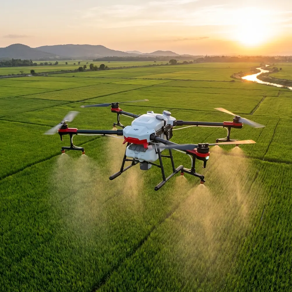
The Agras T50 is often discussed through an agriculture lens, but in mountain utility logistics, its value shows up somewhere less glamorous: repeatability. When crews need to move light materials, pilot ropes, or small tools to difficult spans near steep terrain, the aircraft is not just carrying payload. It is solving a geometry problem under wind, slope, and signal pressure.
That is why flight altitude deserves more attention than it usually gets.
A lot of operators ask for the “best altitude” as if there is one fixed number. In mountain line work, there isn’t. The correct height is not something you wait for the site to reveal. You actively look for order in the environment, then build your profile around it. That idea comes from an unexpected place: a recent piece on minimalist photography argued that strong results do not come from waiting for perfect weather or a perfect scene, but from finding visual order with very few elements. The same principle applies here. A mountainside, two towers, a conductor corridor, a gusting ridge, and a delivery point may look chaotic at first. The job becomes safer and more efficient when you reduce that scene to its governing lines.
With the T50, altitude is one of those governing lines.
Start with the corridor, not the aircraft
On power line delivery missions at elevation, many teams begin by reviewing aircraft capability first. That is backwards. Start with the corridor itself:
- slope angle below and beside the line
- relative tower height
- conductor sag between structures
- terrain-induced wind acceleration
- available approach and exit lanes
- GNSS visibility along the route
Only after that do you decide how the T50 should fly.
In broad terms, your working altitude should be based on clearance consistency, not just obstacle clearance. A flight path that is technically high enough at one point may still be poor if terrain rises sharply beneath it or if rotor wash and lateral corrections increase near the delivery zone. In mountain utility work, the cleaner route is usually the one that preserves the most stable distance relationship between the drone, the line corridor, and the drop or handoff point.
That matters because the T50 is most effective when its corrections stay small. If the aircraft is constantly climbing and descending to chase terrain, every control input starts to compound: power demand rises, pendulum effects become more noticeable, and final placement becomes less clean.
The best flight altitude is usually “boring”
This sounds counterintuitive, but the best altitude for high-altitude delivery is often the least dramatic one.
Operators sometimes climb too high to “play safe.” The result can be worse:
- more crosswind exposure above the ridge line
- weaker visual judgment near cables and structures
- greater drift during final approach
- less predictable descent geometry to the handoff point
Flying too low has its own penalties:
- stronger terrain turbulence near slopes
- compressed reaction time
- more abrupt obstacle avoidance
- harder recovery options if the approach destabilizes
The sweet spot is typically the altitude band where the aircraft can maintain a calm, nearly level attitude while preserving visual and positional clarity against the line corridor. For many mountain delivery tasks, that means choosing a route referenced to the structure and conductor environment, not simply to takeoff elevation.
Think of it like framing a minimalist image. A pure blue wall, a single pedestrian, one cloud—those examples work because the clutter is stripped away until the important relationships become obvious. In the field, your version of minimalism is a route that removes unnecessary vertical motion and unnecessary lateral correction. If the T50 can hold a simple, readable path, the delivery gets better.
Why centimeter-class positioning matters more in mountains
The T50 conversation often includes terms like RTK fix rate and centimeter precision, and in this scenario they are not marketing decoration.
In high-altitude power line delivery, precise positioning affects three practical things:
1. Predictable stop points
When the aircraft pauses near a handoff or drop zone, small position errors can become large operational problems. A drone that drifts a little over open field is inconvenient. A drone that drifts a little beside a tower face or toward a conductor corridor creates workload and risk for the crew.
2. Cleaner repeat runs
Utility teams rarely do these jobs only once. They repeat spans, repeat approaches, and revisit routes. Centimeter-level consistency makes those repeat missions more trainable and easier to document.
3. Better altitude discipline
Altitude decisions only work if the aircraft can actually hold the intended path. Good RTK behavior supports the practical value of your chosen flight band. If your fix rate is poor, your “optimal altitude” on paper may collapse in the air because the platform is making too many corrections.
For this reason, do not separate altitude planning from RTK planning. They are connected. If the terrain creates weak satellite visibility in one section of the corridor, that may be enough to move your route or change your altitude profile even if obstacle clearance looked acceptable.
Weather is not a waiting game
Some crews delay too long, hoping for the “perfect window.” That is rarely how mountain utility schedules work.
The more useful mindset is to identify the kind of atmospheric order you need. Again, the minimalist photography reference is surprisingly relevant: the strong image does not come from luck but from recognizing order. In line delivery, the question is not whether conditions are ideal. It is whether the wind behavior is legible enough to support a controlled route.
At high altitude, pay special attention to:
- ridge-top crosswinds
- valley channeling
- rotor zones on the lee side of terrain
- temperature-driven changes across the work period
- payload-induced braking distance on descent
A route that looks acceptable at launch can become unstable near midday if slope heating changes local air movement. This is one reason “optimal altitude” should never be copied from a previous mission without fresh assessment.
The aircraft’s environmental durability also matters. Operators often value robust weather protection on utility jobs because mountain sites are rarely clean, dry, and forgiving. A platform associated with an IPX6K-level protection class is relevant here not as a brochure statistic, but because moisture, dust, and splash exposure are normal around rough access roads and field staging areas. That does not make bad weather acceptable. It does reduce the fragility of the operation.
Build the mission in three altitude zones
For the T50, I recommend thinking in three zones rather than one number.
Zone 1: Transit altitude
This is the segment from takeoff to the line corridor. The goal is efficiency and terrain separation, not final precision. Keep it high enough for a clean path, but not so high that you move into stronger, less predictable crossflow.
Zone 2: Working altitude
This is the most important band. Here the drone should align with the operational geometry of the task: tower access, conductor spacing awareness, crew visibility, and stable payload behavior. This is where you want the route to feel almost uneventful. If the aircraft is constantly correcting, the altitude is probably wrong, the lane is wrong, or both.
Zone 3: Delivery altitude
This is the final handoff or placement segment. It is usually lower and slower, but not necessarily “as low as possible.” The right height is the one that gives the ground or tower crew a clear, predictable interaction while preserving escape options for the pilot.
Breaking the mission into zones stops operators from chasing one magic altitude for the entire route.
Don’t import agriculture habits blindly
The T50 has roots in agricultural workflows, so some habits carry over poorly into power line logistics.
For example, ag operators often think in terms such as swath width, nozzle calibration, spray drift, or multispectral data workflows. Those concepts are useful in their own environment, but high-altitude delivery asks different questions. Your equivalent of swath management is corridor discipline. Your equivalent of drift concern is payload path deviation in crosswind. Your equivalent of calibration is repeatable approach geometry.
The lesson is simple: use the aircraft’s strengths, but translate them properly.
That said, one crossover idea does matter: disciplined setup. In training systems like DJI’s educational TT platform, even basic connection logic teaches a serious operational principle. The training material notes that a unit without an expansion module broadcasts WiFi under Tello, while a unit fitted with the expansion module shows RMTT, and connection status is verified visually when the software indicator changes from an alert symbol to a green check. It also specifies that after upload-mode programming, the device should be reset until the matrix display shows “TT” before switching back to real-time mode.
Why bring that up in a T50 power line article? Because it highlights something many field teams neglect: mode awareness.
On utility jobs, confusion about connection state, control state, or mission state creates preventable errors. The exact labels are different on the T50, but the discipline is identical. Before a high-altitude delivery run, the crew should have unmistakable confirmation of:
- control link status
- positioning status
- mission mode
- payload attachment status
- emergency recovery plan
The TT example is small, but the operational significance is large: do not assume the aircraft is in the state you think it is. Verify it in a way the whole team understands.
How to choose the optimal altitude on site
Here is the field method I use with crews.
Step 1: Stand where the delivery matters
Do not assess only from takeoff. Walk to the tower base, slope edge, or receiving point. Look outward from the point where precision matters most.
Step 2: Identify the cleanest visual lane
Find the route with the least clutter in relative terms: fewer abrupt terrain rises, fewer background conflicts, fewer moments where the aircraft visually merges with structures or cables.
Step 3: Test for wind layers, not just wind speed
A route can be calm near launch and unstable higher up. If available, conduct a non-delivery reconnaissance pass at graduated heights.
Step 4: Favor stable geometry over shortest distance
The shortest line between two points may cut through the worst air. A slightly longer path with steadier attitude control is usually the better delivery path.
Step 5: Lock in a repeatable working band
Once you find the altitude band where the T50 tracks cleanly and the crew can read the aircraft clearly, keep the mission centered there unless conditions force a change.
Step 6: Brief the escape route
Every delivery approach should have a simple abort direction and climb or retreat plan that avoids line conflict.
A practical rule for mountain missions
If you remember one thing, remember this:
Choose the altitude that reduces corrections, not the altitude that merely clears obstacles.
That single shift improves delivery quality more than most teams expect.
It also helps explain why some operators struggle even when they have a capable aircraft. They are solving the wrong problem. They ask, “How high do I need to be?” when the better question is, “At what height does the aircraft stop fighting the corridor?”
Once you ask it that way, the route becomes easier to build.
When to adjust on the fly
Even a well-planned altitude can become wrong during the mission. Adjust if you see:
- repeated lateral drift near one terrain feature
- inconsistent hover hold at the intended handoff point
- growing pilot workload in the same section each run
- crew difficulty judging the aircraft’s distance from the line
- delayed braking or swing due to wind exposure
When that happens, don’t just blame weather. Re-check geometry. A small altitude change can move the aircraft out of a turbulent layer and restore control quality.
Final thought from the field
The T50 can be a serious tool for high-altitude utility delivery, but only when operators stop treating altitude like a default setting. Mountain line work is not won by brute capability. It is won by disciplined simplification.
Find the order in the scene. Strip out unnecessary movement. Keep the aircraft in the altitude band where it can hold its line without drama.
If your team is planning a route and wants a second set of eyes on altitude strategy, corridor setup, or RTK behavior for a specific site, you can send the mission details here.
Ready for your own Agras T50? Contact our team for expert consultation.