Delivering Through Thin Air: What a 5,380-Meter Heavy
Delivering Through Thin Air: What a 5,380-Meter Heavy-Lift Record Teaches Agras T50 Operators in Power-Line Terrain
META: A field-focused Agras T50 tutorial for complex terrain missions, using a 5,380-meter heavy-lift drone record to explain payload planning, weather response, RTK discipline, and safer high-altitude delivery workflows.
By Marcus Rodriguez, Consultant
If you work around mountain transmission corridors, you already know the real problem is not simply getting a drone into the air. It is keeping that aircraft predictable when the environment strips away margin.
That is why a recent Chinese heavy-lift drone milestone deserves attention from Agras T50 operators, even though the aircraft in the headline was not a T50. In Tibet’s Nagqu Amdo County, at a test point in Duoma Township, a multirotor heavy-lift platform reportedly hovered at 5,380 meters, carried a 30-kilogram suspended load, held it steady, and flew for 15 minutes before landing accurately. The most significant detail is not the headline value by itself. It is the atmospheric context: at that elevation, air density was said to be only 60% of what you get on the plains.
For anyone planning utility-support delivery in broken terrain, that single fact changes the way you should think about mission design. Thin air reduces rotor efficiency, narrows control headroom, stretches power demands, and makes every mid-flight change in wind behavior more consequential. The story also included another operational clue that matters: the test team drove 11,078 kilometers to reach the site, including a 600-kilometer uninhabited stretch. Serious mountain drone work is logistics-heavy before the motors even spool up.
So what does this mean for an Agras T50 user delivering line hardware, insulator components, tools, or emergency support items in difficult terrain? Quite a lot.
Why this record matters to Agras T50 crews
The wrong way to read the Tibet test is as a broad claim that every agricultural drone can now perform high-altitude sling-load work without compromise. The right way is to treat it as proof of what thin-air operations demand from aircraft design, pilot discipline, and mission planning.
The reported test aircraft, the JDY-100B, was described with a maximum takeoff weight of 221 kilograms and an effective payload potential of 100 kilograms. Those numbers tell us the record was not a casual demonstration. It was a controlled expression of reserve capacity under punishing environmental conditions. When a platform can stabilize a 30-kilogram suspended load where the atmosphere is far less supportive, that says something about propulsion authority, control tuning, and payload management.
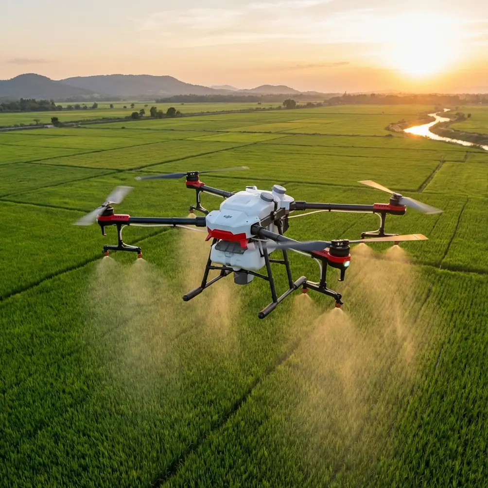
For Agras T50 operators, the lesson is not “copy the record.” The lesson is “respect the margin.” The T50 is often discussed through an agricultural lens, but in rugged utility-adjacent operations, the same fundamentals apply: rotor authority, precision positioning, obstacle awareness, payload realism, and weather judgment.
If you are moving items along power-line routes, especially in valleys, saddle crossings, ridgelines, and spur access points, your mission difficulty can spike fast. Airflow near towers and terrain is rarely smooth. Downdrafts and rotor wash interactions can destabilize a package or change the behavior of a suspended line. A delivery that feels routine on a lowland access road can become demanding at elevation.
Start with the atmosphere, not the aircraft brochure
When air density falls, your drone does not stop flying. It simply has to work harder for the same result.
That matters in three ways.
First, lift efficiency drops. The motors and propellers need to generate more effort to maintain altitude and control, especially with payload attached. Second, battery consumption rises relative to useful work completed. Third, the aircraft becomes less forgiving when the weather shifts mid-flight.
That last point is where most field plans are too optimistic.
A mountain mission may launch in calm conditions, then run into lateral gusts as the sun warms a slope, or encounter a crosswind at a ridgeline gap that was not present at takeoff. In a power-line delivery scenario, that is not just uncomfortable. It affects route choice, speed, package stability, and landing confidence.
I have seen crews focus heavily on payload weight while underestimating payload behavior. That is a mistake. A compact rigid item and a long awkward component may weigh the same, yet react very differently once the air starts moving unpredictably.
The Tibet test matters because the 30-kilogram load reportedly remained steady under sling suspension during hover and flight. Operationally, that stability is the story. In complex terrain, stable transport protects the aircraft, the cargo, and the receiving crew.
A practical Agras T50 tutorial for power-line delivery terrain
Below is the workflow I recommend when adapting Agras T50 operations to complex delivery environments.
1. Build your mission around density altitude, not just field elevation
Pilots often talk about elevation as if it tells the whole story. It does not. Temperature and local pressure conditions shape how “thin” the air behaves on the day of flight. A route that was manageable one morning can feel very different in a warmer afternoon window.
Before launch, classify the mission into one of three envelopes:
- Conservative payload, short route, broad landing margin
- Moderate payload, structured route, defined alternates
- Tight margin mission, where one variable shift can force abort
Most crews should operate in the first two categories unless they have repeated site experience and verified performance data.
2. Keep payload geometry under control
For utility delivery, everyone asks, “How many kilograms?” Fewer ask, “How will it swing?”
That question matters more than many operators realize. The test report highlighted a suspended 30-kilogram load holding steady for 15 minutes. Stability under suspension is not automatic. It is engineered and managed.
With an Agras T50, the practical takeaway is to minimize pendulum behavior:
- Keep the suspension length as short as the task allows
- Use balanced rigging points
- Avoid shapes that weathercock in crosswinds
- Test the package low and close before committing to the route
If weather changes mid-flight, a stable payload gives you options. An unstable one starts making decisions for you.
3. Route around airflow traps, not just terrain obstacles
A map shows cliffs, towers, and ravines. It does not show the air.
In mountain power-line corridors, the dangerous zones are often:
- Ridge crests where wind accelerates
- Valley mouths where flow channels and turns
- Leeward slopes where turbulence rolls off terrain
- Tower approaches with complex localized airflow
Your T50 route should avoid these areas when loaded, even if the geometric path is longer. A direct line is not always the safer line.
4. Treat RTK fix rate as a risk control, not a nice-to-have
In complex terrain, centimeter precision is only useful if your positioning remains reliable throughout the mission. That is where RTK discipline matters.
A strong RTK fix rate helps the aircraft maintain consistent path tracking and repeatable approach behavior, especially when terrain and infrastructure narrow your margin. Around power lines, small positional deviations matter. They matter more when the aircraft is carrying an external load and the wind begins to move it off axis.
If your RTK environment is compromised by terrain masking or signal inconsistency, downgrade the mission. Do not keep the same route and simply “fly more carefully.” That is not a substitute for navigation integrity.
5. Use weather triggers, not vague weather awareness
“Watch the weather” is not a procedure.
Define trigger points before takeoff:
- Maximum acceptable crosswind at departure
- Maximum gust spread
- Abort threshold for payload oscillation
- Minimum battery reserve for reroute or hold
- Visibility floor for approach continuation
This is where the Tibet record offers a subtle but valuable lesson. The aircraft’s successful hover and accurate recovery in thin air suggest a platform operated with clear performance boundaries, not improvisation.
For the Agras T50, that means you need pre-committed decision rules. If the weather changes mid-flight and the aircraft begins using noticeably more control authority to hold line, slow down, shorten exposure, and move to the safest recovery option. Do not chase the original plan because the package is “almost there.”
What to do when weather changes mid-flight
This is the scenario many operators underestimate. Conditions look acceptable. The drone is en route. Then the wind shifts at the ridgeline crossing.
Here is the disciplined response.
First, reduce groundspeed. Fast flight with a suspended load in fresh turbulence compounds instability. Second, stop trying to salvage the most efficient route. Shift to the safest available corridor, even if it adds distance. Third, watch payload motion, not just aircraft attitude. The drone can remain flyable while the load becomes the real hazard. Fourth, protect landing quality. A rushed drop zone approach in gusting air is where near-misses multiply.
On the T50, this is also where system readiness matters. IPX6K-level protection is valuable in ugly field conditions, but weather resistance is not permission to ignore changing airflow, visibility, or surface conditions at the landing site. Moisture tolerance and operational survivability are helpful. They do not repeal aerodynamics.
Borrow the agricultural discipline, not just the hardware
Agras platforms bring habits from precision fieldwork that are surprisingly useful in utility delivery settings.
Nozzle calibration and spray drift may seem unrelated to power-line logistics, but the mindset behind them is exactly right. Good ag operators understand that environmental conditions can alter where material goes, how evenly it is applied, and whether the mission should proceed at all. Replace droplets with a suspended package, and the thinking still holds. If the environment pushes your payload off intended behavior, the mission quality degrades and the safety risk rises.
Swath width awareness also carries over conceptually. In crop work, it is about coverage efficiency and overlap. In delivery work, it translates into corridor width discipline. How much lateral room do you truly have for safe transit, hover correction, and final placement? In complex terrain, operators often overestimate that space.
Even multispectral workflows offer a lesson. The best crews do not rely on a single source of truth. They combine data layers before acting. Delivery teams should do the same with terrain review, live weather checks, route reconnaissance, and receiving-site readiness.
The logistics story behind the headline
One of the most useful details in the report was not airborne at all. A four-person flight-test team drove a box truck from Xi’an through Lanzhou, Qinghai, and Xinjiang, crossed a 600-kilometer no-man’s-land stretch, and reached the Tibet test location after an 11,078-kilometer journey.
Why does that matter to an Agras T50 reader?
Because remote drone success is usually decided by field support quality long before flight. Mountain operations punish weak logistics:
- Spare parts that are “probably enough” are not enough
- Power planning must account for charging delays and altitude effects
- Crew fatigue becomes a flight safety factor
- Route scouting and contingency landing zones matter as much as aircraft capability
If your power-line delivery concept depends on a single launch point, a single route, and a single weather assumption, it is fragile. The teams that perform well in hard terrain build redundancy into everything.
A realistic standard for Agras T50 operators
The Tibet record should not push operators toward bravado. It should push them toward sharper standards.
Use the story for what it really offers: evidence that high-altitude multirotor transport is advancing fast, but only when hardware capability is matched by disciplined execution. Thin air at 5,380 meters, a 30-kilogram suspended load, and a stable 15-minute flight are not just impressive numbers. They are operational reminders that lift, control, route planning, and weather response must all hold together at once.
For Agras T50 work in power-line terrain, the winning mindset is simple:
- Plan for less margin than you hope to have
- Validate payload behavior before range matters
- Protect RTK reliability
- Reroute early when airflow turns hostile
- Build the mission like logistics can fail, because sometimes they do
That is how you turn a headline from another aircraft category into useful field doctrine for your own operations.
If you are designing a delivery workflow for transmission support in mountain terrain and want a second set of eyes on payload method, route structure, or RTK assumptions, you can share the mission profile here: message me directly about your T50 field plan
Ready for your own Agras T50? Contact our team for expert consultation.