Agras T50 Guide: Mastering Highway Delivery Terrain
Agras T50 Guide: Mastering Highway Delivery Terrain
META: Discover how the Agras T50 conquers complex highway construction terrain with RTK precision and intelligent obstacle avoidance for reliable material delivery.
TL;DR
- Agras T50 delivers up to 50kg payloads across rugged highway construction zones where ground vehicles fail
- Centimeter precision RTK positioning ensures accurate drops on narrow work platforms and bridge segments
- Dual FPV cameras and phased array radar navigate wildlife, cables, and unpredictable terrain obstacles
- IPX6K rating keeps operations running through dust storms and sudden mountain weather shifts
The Highway Construction Challenge Nobody Talks About
Highway construction through mountainous terrain creates logistics nightmares that cost contractors millions in delays. Traditional delivery methods—trucks navigating switchbacks, helicopters burning fuel at premium rates—simply cannot keep pace with modern construction timelines.
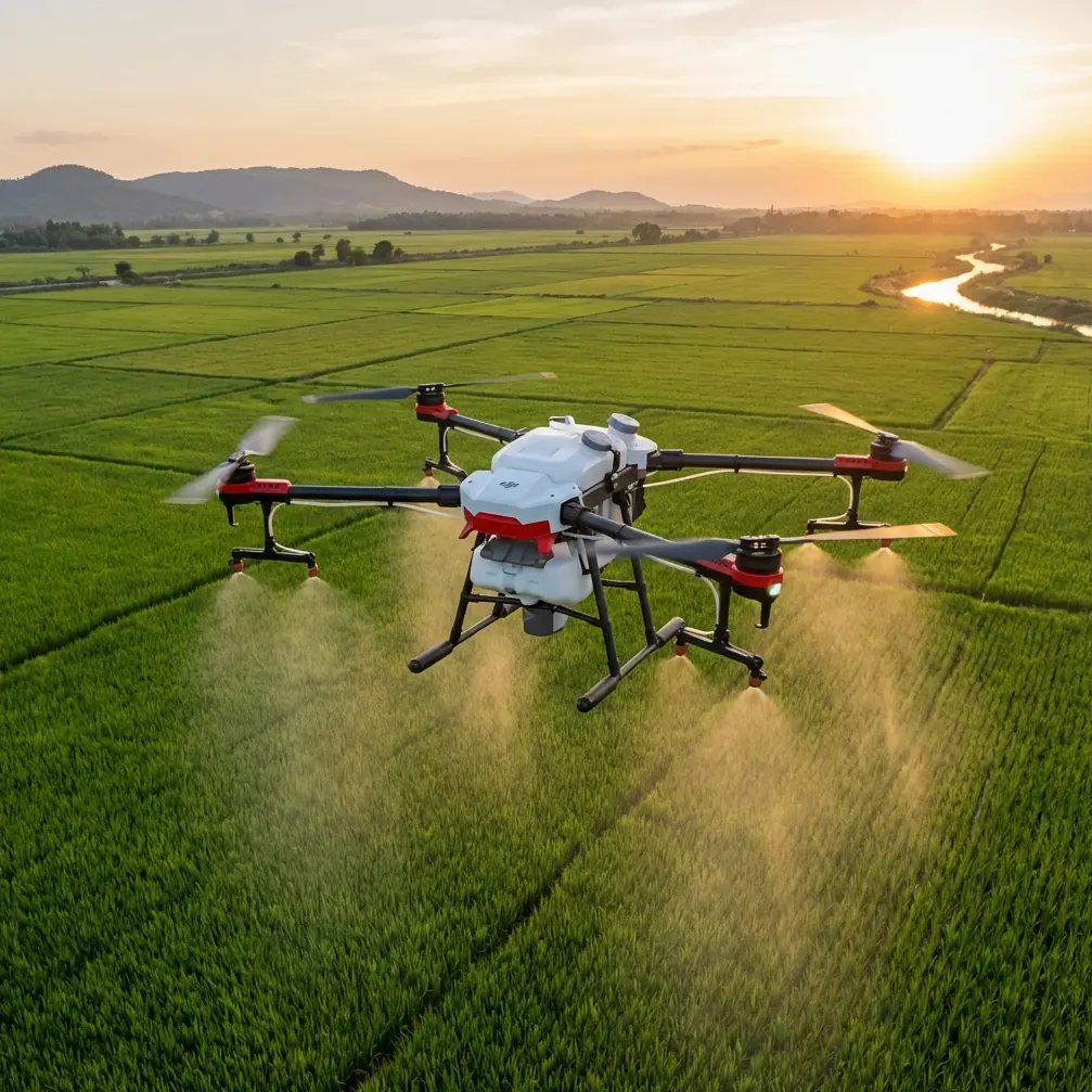
The Agras T50 changes this equation entirely. This agricultural powerhouse, originally designed for precision spraying across 50-acre fields, has found an unexpected second life delivering critical materials to highway construction crews working in impossible locations.
This guide breaks down exactly how the T50's specifications translate to real-world highway delivery performance, including a memorable encounter with local wildlife that tested every sensor system onboard.
Why Highway Terrain Demands Agricultural-Grade Drones
The Unique Challenges of Linear Construction Sites
Highway projects stretch across miles of varying elevation, soil conditions, and microclimates. A single project might span:
- River gorges requiring bridge segment assembly
- Cliff faces where workers anchor retaining walls
- Dense forest corridors with limited helicopter landing zones
- Active wildlife migration paths crossing construction zones
Ground-based delivery faces constant interruptions. A supply truck navigating a 12% grade switchback might take 45 minutes to cover distance a drone crosses in 3 minutes.
Why the Agras T50 Specifically?
The T50 wasn't designed for construction delivery—it was built to spray pesticides across massive agricultural operations with swath width coverage of 11 meters. This origin story matters because agricultural drones face remarkably similar challenges:
- Unpredictable terrain elevation changes
- Wind shear from thermal columns
- Obstacle-dense environments (trees, power lines, structures)
- Payload precision requirements measured in centimeters
Expert Insight: Agricultural spray operations demand the same positional accuracy as construction delivery. A 2-meter drift in pesticide application destroys crops; a 2-meter drift in material delivery drops supplies off a cliff. The T50 treats both scenarios with identical seriousness.
Technical Specifications That Matter for Highway Delivery
Payload and Flight Performance
The T50's specifications translate directly to construction utility:
| Specification | Agricultural Use | Highway Delivery Application |
|---|---|---|
| Max Payload | 50kg spray tank | Concrete anchors, cable spools, tool kits |
| Flight Time | 11 min (full load) | 8-10 min accounting for altitude gains |
| Max Speed | 10 m/s (spraying) | 15 m/s (transit mode) |
| Operating Altitude | 30m above crops | 150m+ above valley floors |
| Wind Resistance | Level 6 (13.8 m/s) | Critical for mountain thermals |
| RTK Fix Rate | 95%+ in open fields | 85-92% in canyon environments |
The RTK Positioning Advantage
Standard GPS provides 2-5 meter accuracy—acceptable for recreational drones, catastrophic for construction delivery. The T50's RTK (Real-Time Kinematic) system achieves centimeter precision by comparing satellite signals against a ground-based reference station.
For highway delivery, this means:
- Drops land within 10cm of target coordinates
- Repeated deliveries to the same location stack precisely
- Narrow bridge platforms and scaffolding become viable targets
- Night operations maintain daytime accuracy levels
The RTK fix rate becomes critical in canyon environments where satellite visibility drops. The T50 maintains positioning lock even when only 60% of the sky remains visible—a scenario common in deep highway cuts through mountainous terrain.
Navigating the Unexpected: A Wildlife Encounter
During a material delivery operation on a Pacific Northwest highway project, the T50's sensor suite faced an unplanned test. The drone was transporting a 35kg spool of tensioning cable to a bridge crew working 200 meters below the staging area.
Midway through descent, the phased array radar detected movement—a juvenile bald eagle investigating the unfamiliar object in its airspace. The bird approached from the drone's 4 o'clock position, well outside the pilot's direct line of sight.
The T50's response demonstrated why agricultural obstacle avoidance translates perfectly to construction environments:
- Phased array radar detected the approaching object at 45 meters
- Dual FPV cameras provided visual confirmation to the ground operator
- Automatic hover engagement paused the descent
- Lateral drift moved the drone 8 meters east, away from the eagle's flight path
- Descent resumed after 12 seconds of clear airspace
The cable spool reached its target within 7cm of planned coordinates. The eagle continued its patrol unbothered.
Pro Tip: Program wildlife encounter protocols into your flight planning software. The T50's obstacle avoidance works automatically, but having predetermined "hold and drift" waypoints prevents the drone from backing into secondary obstacles while avoiding the primary threat.
Spray Drift Technology Repurposed for Precision Drops
The T50's spray drift compensation system—designed to prevent pesticide from landing on neighboring crops—provides unexpected benefits for material delivery.
How Spray Drift Compensation Works
Agricultural spraying requires predicting where liquid droplets will land based on:
- Wind speed and direction at multiple altitudes
- Droplet size (controlled by nozzle calibration)
- Release height above target
- Forward flight speed
The T50 continuously calculates these variables, adjusting spray timing to compensate for drift. For delivery operations, this same computational framework predicts where released payloads will land.
Practical Application for Highway Delivery
When dropping materials to a moving construction platform (common during bridge assembly), the T50's drift compensation calculates:
- Platform movement speed and direction
- Wind effects on the payload during freefall
- Optimal release point for target intercept
This transforms what would be a dangerous "best guess" drop into a predictable, repeatable delivery system.
Multispectral Capabilities for Site Assessment
The T50's multispectral imaging options—originally designed to assess crop health—provide construction teams with valuable site intelligence.
Beyond Visible Light
Multispectral sensors capture data across multiple wavelength bands:
- Near-infrared (NIR): Reveals moisture content in soil and vegetation
- Red edge: Identifies stressed vegetation before visible symptoms appear
- Thermal: Detects temperature variations indicating subsurface water or voids
For highway construction, these capabilities translate to:
- Slope stability assessment through vegetation stress patterns
- Drainage mapping via moisture content analysis
- Equipment heat signatures for site activity monitoring
Common Mistakes to Avoid
Underestimating Altitude Effects on Payload Capacity
The T50's 50kg maximum payload assumes sea-level air density. At 2,000 meters elevation—common for mountain highway projects—effective lift drops by approximately 15%. Plan for 42kg maximum at altitude.
Ignoring Microclimate Wind Patterns
Mountain highways create their own weather. Morning thermal updrafts reverse to afternoon downdrafts. Canyon walls accelerate wind speeds unpredictably. Always conduct test flights with minimal payload before committing to heavy delivery operations.
Skipping Nozzle Calibration Procedures
Even when not spraying, the T50's nozzle calibration routines verify sensor accuracy and motor response. These self-tests catch developing issues before they cause mid-flight failures. Run calibration before every delivery session.
Treating RTK as Infallible
RTK positioning requires clear sky visibility and functioning base stations. Canyon environments degrade both. Always have manual override procedures ready and train pilots on visual positioning backup methods.
Neglecting IPX6K Limitations
The T50's IPX6K rating protects against powerful water jets—excellent for rain and dust. It does not protect against submersion. Avoid operations where crash recovery might require underwater retrieval.
Frequently Asked Questions
Can the Agras T50 legally deliver materials to highway construction sites?
Regulations vary by jurisdiction, but most countries classify the T50 as a commercial agricultural drone. Construction delivery typically requires additional permits beyond standard agricultural authorizations. In the United States, Part 107 waivers for operations over people and beyond visual line of sight are commonly required. Work with local aviation authorities and your construction project's safety officer to establish compliant operations.
How does the T50 compare to purpose-built delivery drones for construction applications?
Purpose-built delivery drones often sacrifice payload capacity for specialized drop mechanisms. The T50's 50kg capacity exceeds most dedicated delivery platforms by 2-3x. Its agricultural heritage means replacement parts and service expertise are widely available—critical for remote construction sites. The tradeoff is manual payload attachment rather than automated loading systems.
What maintenance schedule should highway delivery operations follow?
Agricultural operations typically service the T50 every 100 flight hours or 500 hectares sprayed. Construction delivery—with its higher stress from altitude changes and heavier payloads—should compress this to 75 flight hours. Pay particular attention to motor bearings, propeller balance, and RTK antenna connections. The phased array radar requires recalibration every 200 hours or after any significant impact event.
Ready for your own Agras T50? Contact our team for expert consultation.