Agras T50 for Forest Corridors and Remote Delivery: A Field
Agras T50 for Forest Corridors and Remote Delivery: A Field-First Guide
META: A practical expert guide to using the Agras T50 in remote forest operations, with insights on aerial medical logistics, hyperspectral decision-making, weather shifts, precision flight, and operator training.
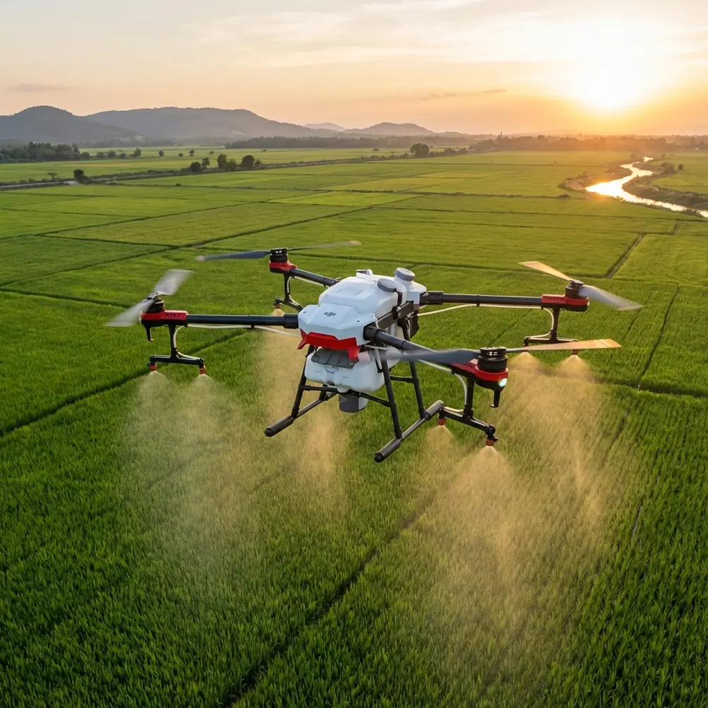
The Agras T50 is usually discussed as an agricultural workhorse. That framing is useful, but incomplete. In remote forest environments, especially where road access is unreliable, the more interesting question is not just how much area the aircraft can cover. It is whether the platform can become part of a larger operational chain: sensing, decision-making, delivery, and repeatable execution under changing conditions.
That matters because forests are where logistics get expensive, slow, and fragile. A washed-out road, a steep ravine, or a long drive between access points can turn a simple task into a half-day delay. The reference materials behind this article point to two very specific shifts in the drone sector that help explain why a platform like the T50 deserves attention beyond routine spraying.
First, China is actively using drones to build what the source calls an “air corridor for life,” moving medical supplies, emergency equipment, and test samples faster when ground traffic is blocked or distances are long. Second, hyperspectral remote sensing has shown that detailed spectral analysis can estimate forest canopy closure with accuracy close to 85%, and in one cited regression model, 86.34%. Put those together and a clearer picture emerges: the modern drone operation in forests is no longer just about flying. It is about connecting payload movement with better environmental intelligence.
That is exactly the lens I use when evaluating the Agras T50 for forest-adjacent work.
Why the T50 is relevant in remote forests
A forest mission exposes weaknesses quickly. GNSS conditions can be uneven under canopy edges. Moisture, mud, and debris are constant. Wind patterns shift around tree lines. Landing zones are rarely ideal. Operators do not need a pretty spec sheet; they need a system that still makes sense once the weather changes and the route is no longer neat.
The T50’s value starts with its role as a heavy-duty civilian utility aircraft. Even if your core use case is agricultural treatment along forest belts, tree nurseries, firebreak edges, access roads, or restoration plots, the aircraft becomes more valuable when it can support adjacent workflows: delivering urgent materials to a remote team, carrying diagnostic payloads to a staging point, or operating as one asset inside a broader land-management program.
That broader view is where many buyers either overestimate or underestimate the aircraft.
They overestimate it if they assume one drone replaces every field process. It does not.
They underestimate it if they only see it as a sprayer.
In forest operations, the best T50 deployments are disciplined. The aircraft handles repetitive aerial work. Other sensors, maps, and trained crews handle diagnosis and planning. This is where the hyperspectral reference becomes more than an academic aside.
Forest operations need better inputs, not just more flights
One of the source documents explains why hyperspectral imaging matters in forest analysis. Conventional remote sensing often struggles because it has fewer, broader bands, which can lead to false similarity between different materials or false difference within the same material. Hyperspectral data, by contrast, treats each pixel more like a spectral signature. That allows mixed-pixel decomposition with much higher confidence.
Operationally, that is a big deal.
If a forest manager is trying to understand canopy closure, stress distribution, or early shifts in vegetation condition, rough imagery can send crews to the wrong block or cause treatment to be applied too broadly. The document cites canopy estimation accuracy reaching nearly 85%, and another model reaching 86.34% after selecting 6 high-correlation components from 16 transformed components. Those are not trivial improvements. They indicate that better sensing can narrow treatment zones and improve how often the aircraft is dispatched to the right place.
The T50 itself is not a hyperspectral mapping platform in the same sense as a specialized remote-sensing drone. But in a real operation, that distinction is healthy rather than limiting. You use hyperspectral or multispectral intelligence to determine where intervention is justified. Then you send the T50 to execute the high-throughput job: targeted application, corridor servicing, or transport to a remote field team.
This separation of roles reduces waste. It also helps with one of the biggest forest-operation problems: spray drift and over-application near sensitive vegetation boundaries.
A practical T50 workflow for remote forest delivery and treatment
When readers ask me whether the T50 fits remote forest work, I usually break the answer into four layers.
1. Mission definition
Do not start with the aircraft. Start with the bottleneck.
If the problem is delayed access to a ranger team, a field medic, or a forestry inspection crew, then the model from the medical emergency reference is the right one: use drones to move compact, high-urgency items when roads are compromised or distance is the real enemy. The source specifically highlights transport of medical supplies, emergency devices, and test samples. In a remote forest context, the same logic applies to civilian support items such as first-aid materials, diagnostic kits, radios, or lightweight maintenance parts delivered to a staging point.
If the problem is vegetation management, define whether the mission is treatment, scouting support, or both. A T50 sent into a poorly defined forest task usually ends up doing too much, too broadly.
2. Data before dispatch
This is where many operations still behave like it is 2018.
If you already have multispectral or hyperspectral layers, use them. The source material on hyperspectral imagery makes the case clearly: more refined spectral interpretation can avoid the classic remote-sensing traps of confusing unlike materials or splitting similar ones incorrectly. In forest blocks, that can mean the difference between treating a real stress zone and treating a shadow artifact.
Even if your final field execution is done with a T50, pre-mission intelligence should shape swath width, route order, and refill planning. Precision starts long before takeoff.
3. Aircraft setup and calibration
This is the least glamorous part, which is why it gets neglected.
For remote work, nozzle calibration is not optional. A T50 operating along forest margins faces turbulence, uneven vegetation height, and abrupt airflow changes where open clearings meet tree walls. If flow rate and droplet behavior are not checked carefully, your spray pattern on paper and your spray pattern in reality become two different things.
The same goes for RTK fix rate and centimeter precision. In open agricultural fields, operators can sometimes get away with looser habits because visual alignment is easier and obstacles are fewer. In forest-edge operations, repeatability matters more. You may be flying narrow corridors, avoiding dense stands, or returning to the same treatment zone after weather delays. Centimeter-level positioning is not just a nice metric; it is what keeps repeated passes from becoming guesswork.
4. Execution with contingency discipline
This is where the T50 earns trust.
A recent field scenario comes to mind. We had stable conditions at launch, then a mid-flight weather shift changed the working environment fast. Wind direction started to swing across the edge of the stand, not through it. Light moisture moved in. Visibility was still workable, but airflow became less predictable around the taller trees. This is the moment when poor operators keep pushing because the aircraft is technically still flying.
A better operator changes the mission logic immediately.
We tightened the task area, reduced exposure along the most turbulent edge, and reassessed drift risk rather than forcing the original route. That is the right way to think about the T50 in forests. Not as a machine that “handles anything,” but as a platform that gives a trained crew enough control and stability to make good decisions under pressure.
Ruggedization also matters here. In wet, dirty environments, a high-protection airframe is not a luxury. Forest staging areas are rough on equipment. If your operation expects mud, spray residue, and rain exposure, an IPX6K-style durability expectation belongs in the planning conversation.
The medical logistics lesson applies more than people think
The most valuable insight from the emergency-response reference is not merely that drones can move medical goods. It is why that matters operationally: when roads are blocked or distances are long, drones compress response time.
That principle translates directly into remote forest workflows.
Imagine a restoration crew working beyond practical vehicle access. A small but urgent item is missing. Ground resupply might take hours. A drone mission can bridge that gap. The T50 should not be treated as a universal courier for every forest task, but the “air corridor” idea is strategically sound. In remote work, time lost to terrain compounds quickly. Any aircraft that can reduce dependency on damaged roads or indirect access routes becomes more than a tool; it becomes part of your resilience plan.
That is one reason buyers should evaluate the T50 less as a standalone drone and more as an operational node. How does it fit with your comms plan, your staging points, your GIS layers, your battery rotation, your weather thresholds, and your field crew training? Those questions matter more than spec-sheet comparisons.
Training is the hidden multiplier
The educational reference included a surprisingly practical clue. It outlines a four-week youth drone curriculum, with 2 lessons per week, moving from aerodynamics and model aircraft assembly into quadcopter basics and key modules such as GPS, gyroscopes, and accelerometers. That progression is simple, but it reflects something commercial operators often ignore: reliable field performance comes from structured understanding, not button pushing.
The T50 is not difficult in the same way early UAVs were difficult. But forest operations punish shallow knowledge.
An operator who understands airflow, sensor behavior, positioning logic, and component function will make better decisions when terrain interferes with GNSS, when moisture changes surface conditions, or when the route needs to be rebuilt on the fly. The reference also notes that AI has evolved over more than 60 years into a phase marked by deep learning, cross-domain integration, human-machine collaboration, and autonomous control. Strip away the policy language and there is a practical takeaway: advanced UAV operations increasingly reward teams that can work with automation without becoming dependent on it.
That is exactly the T50 sweet spot.
You want automation for consistency. You still need a human crew that understands when consistency is no longer safe.
Where the T50 fits best in forest-adjacent missions
The strongest T50 use cases around forests tend to share three traits.
First, the mission is repetitive enough to benefit from a purpose-built heavy UAV.
Second, access by road is limited, slow, or weather-sensitive.
Third, there is enough pre-mission intelligence to avoid flying blind.
That can include treatment along forest perimeters, nursery support, corridor maintenance, vegetation management in remote utility or access zones, and transport of urgent lightweight field supplies to isolated crews. It can also include workflows where a sensing platform identifies a probable problem area and the T50 is then sent to execute the physical task.
If you are still deciding how to configure a forest operation around the aircraft, it helps to talk through payload logic, route design, and weather margins with someone who has worked through the ugly details. If useful, you can message our field team directly on WhatsApp to discuss a real deployment scenario.
What experienced operators watch most closely
When using a T50 in remote forest environments, I pay attention to a short list:
- drift behavior at stand edges, not just average wind speed
- nozzle calibration before every serious treatment block
- RTK fix stability near broken terrain and tree lines
- refill and battery logistics, because remote inefficiency multiplies fast
- route redesign discipline when weather changes mid-flight
- the quality of the sensing data that justified the mission in the first place
That last point is worth repeating. Better aircraft do not solve bad targeting. The hyperspectral reference showed why richer spectral data can map canopy characteristics more truthfully and avoid confusion caused by broad-band imagery. If your planning data is stronger, every T50 sortie becomes more defensible and more efficient.
Final perspective
The Agras T50 makes the most sense in remote forest work when you stop treating it as a single-purpose machine. Its real advantage appears when it is integrated into a smarter chain: spectral intelligence for targeting, precision flight for execution, and drone-based logistics for overcoming distance and blocked ground access.
The references behind this article support that view from two angles. One shows that drones are already proving their worth in time-critical civilian delivery by moving medical items through an aerial emergency corridor. The other shows that advanced spectral analysis can push forest estimation accuracy to around 85% and even 86.34%, giving operators a much stronger basis for action. Together, they point toward a more mature model of UAV work in remote environments.
Not more flying for its own sake.
Better decisions, then better flights.
Ready for your own Agras T50? Contact our team for expert consultation.