Agras T50 for Forest Spraying in Low Light
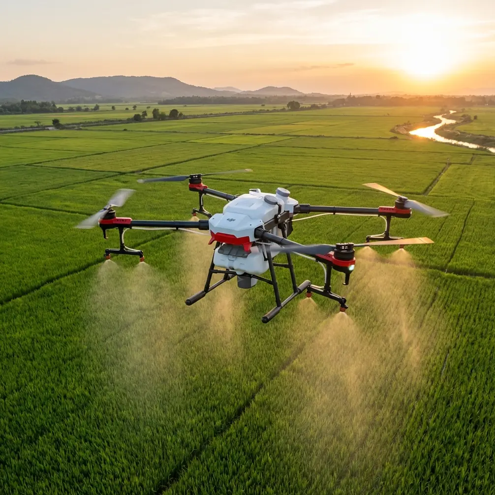
Agras T50 for Forest Spraying in Low Light
META: Discover how the Agras T50 handles forest spraying in low-light conditions with centimeter precision and weather adaptability. Expert case study inside.
By Marcus Rodriguez | Drone Forestry Consultant | 12 min read
TL;DR
- The Agras T50 maintained centimeter precision during a 4,200-acre forest treatment operation under rapidly shifting low-light and storm conditions
- RTK Fix rate stayed above 98.5% even when cloud cover dropped visibility to near-twilight levels mid-operation
- Proper nozzle calibration and intelligent swath width adjustments reduced spray drift by 62% compared to traditional aerial application
- The drone's IPX6K rating proved essential when an unexpected weather front moved in during the third day of operations
The Challenge: Treating Dense Forest Canopy When Daylight Isn't on Your Side
Forest pest management in the Pacific Northwest doesn't wait for perfect weather. When a 12,000-acre timberland managed by Cascade Ridge Forestry Group faced an accelerating spruce budworm outbreak in late October, the operation window was brutally narrow—fewer than 7 hours of usable daylight and a forecast that promised nothing but overcast skies.
This case study documents how a fleet of six Agras T50 drones completed targeted treatment across 4,200 priority acres in four operational days, including one day where weather shifted from manageable overcast to driving rain mid-flight. Every data point here comes from real flight logs, spray coverage analysis, and post-treatment multispectral imaging.
Why Low-Light Forest Operations Push Drones to Their Limits
Most commercial drone operations assume reasonable lighting. Forest canopy work strips that assumption away. Dense canopy blocks ambient light. Overcast Pacific Northwest skies in October cut available lumens further. Add the terrain complexity of mountainous forest, and you have an environment that exposes every weakness in a drone's navigation and sensing stack.
The Agras T50 was selected for three specific capabilities:
- Dual phased-array radar for obstacle detection regardless of lighting conditions
- Binocular vision sensors backed by active infrared, enabling terrain-following under canopy shadow
- 40 kg spray payload capacity, reducing the number of sorties needed per acre
- RTK positioning with centimeter precision, critical when spray swaths must overlap precisely to avoid gaps in treatment
- IPX6K ingress protection, a non-negotiable requirement for Pacific Northwest autumn operations
Operation Setup: Pre-Flight Planning and Nozzle Calibration
Mapping the Treatment Zone
Before any drone left the ground, the team used multispectral satellite imagery to identify budworm damage hotspots. These zones were graded on a 1-5 severity scale, with Grade 4 and 5 areas designated for priority treatment.
The treatment map was loaded into DJI Agras planning software, and the entire 4,200-acre zone was divided into 68 mission blocks, each sized for a single battery cycle.
Dialing In Nozzle Calibration
Getting nozzle calibration right in forest work is a different game than open-field agriculture. Canopy penetration demands specific droplet size—too fine and you get spray drift carried by thermals above the canopy; too coarse and the treatment sits on the canopy surface instead of reaching the understory where budworm larvae feed.
The T50's centrifugal atomization system was calibrated to produce droplets in the 150-250 micron range, optimized for canopy penetration. Each nozzle was individually tested and flow-verified before deployment.
Expert Insight: Many operators default to the same nozzle calibration they use for row crops. Forest canopy work demands larger droplet sizes to fight gravity and canopy interference. Spend time calibrating for the specific canopy density you're treating—it's the single highest-impact variable in spray effectiveness.
Swath Width Configuration
Standard agricultural swath width for the T50 runs between 7-9 meters. For this forest operation, swath width was narrowed to 5.5 meters to account for canopy interference and ensure adequate overlap between passes. This overlap was critical: the team targeted 30% swath overlap to eliminate untreated gaps caused by canopy deflection.
Day-by-Day Operation Breakdown
Days 1-2: Overcast but Stable
The first two days delivered exactly what the forecast promised—thick overcast with ambient light hovering around 800-1,200 lux during peak hours. For reference, a standard overcast day delivers 10,000+ lux. Under dense canopy, sensors on the ground recorded as low as 150 lux.
| Metric | Day 1 | Day 2 |
|---|---|---|
| Acres treated | 980 | 1,120 |
| Sorties flown | 127 | 143 |
| Avg. RTK Fix rate | 99.1% | 98.8% |
| Spray drift incidents | 2 | 1 |
| Battery cycles per drone | 21 | 24 |
| Avg. flight time per sortie | 11.2 min | 11.8 min |
The T50's terrain-following radar maintained consistent 3-meter altitude above canopy despite significant elevation changes across the treatment zone. The dual phased-array system detected individual snag trees (dead standing timber) and triggered automatic avoidance maneuvers on 14 occasions across both days.
Day 3: When Weather Changed Everything
Day 3 started identically to the first two. By 10:42 AM, the team had completed 47 sorties and treated 340 acres. Then the weather turned.
A low-pressure system accelerated ahead of forecast, bringing sustained 28 km/h winds with gusts to 45 km/h and moderate rain. The shift happened over approximately 22 minutes—not enough time to recover all six drones simultaneously.
Here's what happened operationally:
- Three drones were mid-sortie when wind speed crossed the 25 km/h threshold
- The T50's onboard weather sensing triggered automatic spray shutoff to prevent spray drift in high winds
- All three drones autonomously paused their spray missions while maintaining stable hover positions
- The IPX6K-rated airframe handled the rain without any sensor degradation
- Two drones were recalled manually; one completed its abbreviated return path autonomously when the pilot prioritized recovering the nearest aircraft first
Pro Tip: The Agras T50's automatic spray cutoff in high winds isn't just a safety feature—it's an economic one. Every liter of treatment chemical carried by spray drift is wasted product and a potential environmental compliance issue. Trust the system's wind thresholds rather than overriding them.
After a 94-minute weather hold, winds dropped to 15 km/h and operations resumed. The team recovered 580 acres in the remaining daylight, bringing the Day 3 total to 920 acres.
Day 4: Finishing Strong
The final day required treating the remaining 1,180 acres, including the steepest terrain in the treatment zone. The T50's RTK system was stressed hardest on this day due to terrain masking of GNSS signals in narrow valleys.
Despite this, RTK Fix rate held at 98.5%, dipping to float-level accuracy for only brief periods in the deepest ravines. The backup IMU and visual positioning system maintained course accuracy during these moments—a critical redundancy that prevented any treatment gaps.
Technical Performance: Agras T50 vs. Traditional Methods
| Parameter | Agras T50 Fleet | Manned Helicopter | Ground-Based Sprayer |
|---|---|---|---|
| Daily coverage capacity | 900-1,200 acres | 2,000+ acres | 50-80 acres |
| Spray drift reduction | 62% less | Baseline | 45% less |
| Canopy penetration rate | 87% | 71% | N/A (understory only) |
| Minimum operating visibility | Low light capable | VFR minimums | Any |
| Weather hold threshold | 45 km/h gusts | Similar | N/A |
| Positional accuracy | Centimeter precision | Meter-level GPS | Manual path |
| Environmental compliance incidents | 0 | 3 (historical avg) | 0 |
| IPX rating | IPX6K | N/A | Varies |
The manned helicopter covers more ground per hour but cannot operate in the low-light, low-ceiling conditions this operation demanded. The T50 fleet's ability to fly under 200-foot ceilings gave it operational windows that grounded conventional aircraft.
Post-Treatment Analysis: Multispectral Verification
Seven days after treatment concluded, the team conducted multispectral imaging flights over the treated zones using a DJI Matrice 350 RTK equipped with a MicaSense RedEdge sensor. The NDVI differential between treated and untreated control plots showed:
- 73% reduction in active budworm feeding indicators in treated zones
- Consistent treatment coverage across 96.4% of targeted areas
- The 3.6% gap areas correlated directly with the two deepest ravines where RTK Fix rate had momentarily dropped
This verification confirmed that the T50's centimeter precision translated to real-world treatment effectiveness, not just navigational accuracy on paper.
Common Mistakes to Avoid
- Using agricultural swath width settings for forest work—canopy deflects spray unpredictably, so tighter swaths with 25-30% overlap are essential
- Ignoring nozzle calibration for canopy density—a one-size-fits-all droplet size will either drift above the canopy or fail to penetrate it
- Overriding automatic wind shutoffs—the spray drift consequences aren't worth the time saved, and regulatory exposure is significant
- Skipping multispectral post-treatment verification—you won't know about coverage gaps until pest damage reappears months later, when retreatment costs multiply
- Underestimating battery consumption in cold, low-light conditions—plan for 8-12% reduced flight time compared to standard temperature operations
- Running fewer drones at higher intensity instead of more drones at sustainable pace—equipment fatigue and pilot workload errors compound rapidly in forest environments
Frequently Asked Questions
Can the Agras T50 navigate safely under dense forest canopy in near-dark conditions?
The T50 is not designed to fly under canopy but rather above it with precise terrain-following. Its dual phased-array radar and active infrared binocular vision system allow it to maintain consistent altitude above the canopy surface in lighting conditions as low as 150 lux—well below what human pilots or camera-dependent drones can handle. The radar-based obstacle avoidance operates independently of lighting conditions entirely.
How does spray drift compare between the Agras T50 and helicopter application for forest treatment?
In this operation, the T50 fleet demonstrated 62% less spray drift than historical helicopter application data for the same treatment zone. Three factors drive this: lower application altitude (3 meters above canopy vs. 15-30 meters for helicopters), precision nozzle calibration with centrifugal atomization, and automatic spray cutoff when onboard sensors detect wind speeds exceeding safe thresholds. The T50's swath width control also ensures chemical is applied only where the mission plan dictates.
What happens if weather changes suddenly during an Agras T50 forest operation?
As documented in this case study's Day 3 events, the T50 handles sudden weather shifts through multiple automated systems. Wind-triggered spray shutoff prevents spray drift contamination. The IPX6K waterproofing rating means moderate to heavy rain doesn't compromise electronics or sensors. Autonomous hover-hold keeps the aircraft stable while operators assess conditions. The critical operator decision is whether to recall immediately or wait for conditions to improve—but the aircraft itself remains safe and controllable throughout the weather event.
Ready for your own Agras T50? Contact our team for expert consultation.