Agras T50 in Mountain Fields: A Field Report on Stability
Agras T50 in Mountain Fields: A Field Report on Stability, Range, and Setup Discipline
META: Practical Agras T50 field report for mountain agriculture, covering flight stability, antenna positioning, RTK discipline, spray accuracy, and why airspace coordination matters in complex terrain.
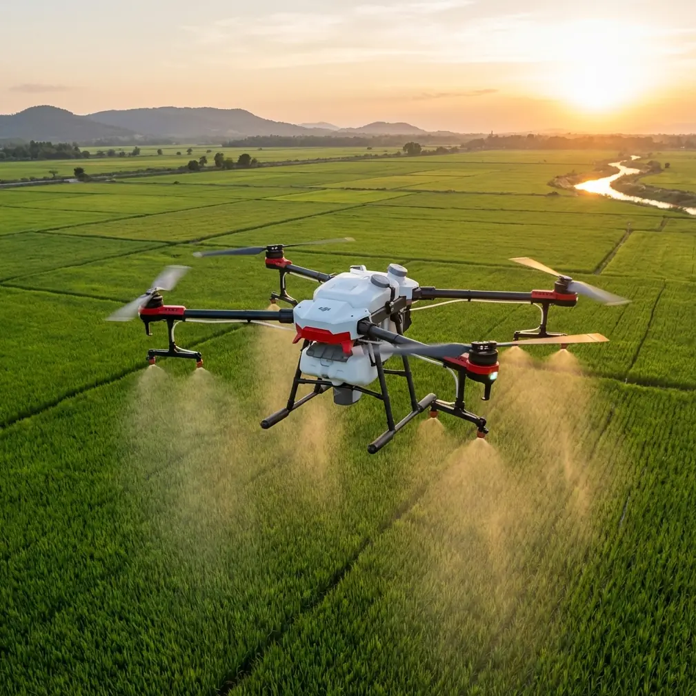
Mountain agriculture exposes every weakness in a drone operation.
That is especially true when the aircraft is expected to do real work rather than look good on a spec sheet. In steep orchards, terraced plots, and broken valleys, an Agras T50 is not just carrying liquid or material from point A to point B. It is constantly negotiating elevation change, signal obstruction, shifting wind, and the simple fact that the margin for sloppy setup is much smaller than it is over a flat field.
I’ve been thinking about that through an unusual combination of source material: a recent hiring notice from the 四川省低空空域运行服务中心, and two technical references that, while not written about the T50 directly, reveal something more useful than marketing copy. They point to the hidden structure behind successful low-altitude operations: airspace services, coordinate discipline, and a sharp understanding of how a multirotor actually holds attitude in demanding terrain.
For readers focused on the Agras T50 in mountain delivery and agricultural work, that matters more than another generic overview.
The mountain-field problem is not payload. It is consistency.
People often frame mountain operations around power, payload, or tank size. Those matter, but in practice the harder issue is consistency across uneven topography.
A quad-style or multi-rotor agricultural platform remains airborne because the flight controller is making relentless, small corrections through motor speed changes. One of the reference documents explains this in simple but foundational terms: vertical movement comes from increasing or decreasing total lift across the motors, while pitch motion is created by reducing front motor speed and increasing rear motor speed, or the reverse. That sounds elementary until you apply it to mountain fields.
On a terraced slope, the T50 is rarely flying in one clean, stable air mass. It encounters ridge turbulence, vegetation-induced gusts, and apparent altitude shifts as the terrain rises beneath it. Every one of those disturbances forces the aircraft to rebalance lift and attitude. If your setup is poor, if your route is careless, or if your signal chain is compromised, the aircraft spends more effort correcting than performing.
That has direct operational consequences:
- spray drift becomes harder to control,
- swath width becomes less uniform,
- nozzle calibration matters more because height above canopy changes faster,
- and delivery precision suffers when approach paths are not planned around slope and signal shadow.
The T50 can handle serious work. But mountain work rewards operators who think like systems managers, not button-pushers.
What the Sichuan hiring notice quietly tells us
At first glance, a recruitment post from the 四川省低空空域运行服务中心 seems far removed from an Agras T50 in a mountain field. It isn’t.
The core fact is simple: Sichuan’s low-altitude airspace operation service center is recruiting, and the wording indicates the positions carry formal public institution staffing status. That is not a trivial bureaucratic note. It signals something bigger—low-altitude drone activity is becoming institutional, managed, and operationally integrated rather than treated as an improvised edge case.
Why should an Agras T50 operator care?
Because mountain delivery and agricultural missions are where fragmented airspace awareness causes real trouble. Valleys compress routes. Hills block visibility. Temporary obstacles appear. Nearby low-altitude activity may include surveying, inspection, training, or agricultural flights. As more regions formalize low-altitude operation services, the best drone teams will be the ones that align with that ecosystem early.
In practical terms, this means a professional T50 workflow in mountainous areas should include:
- pre-mission awareness of local low-altitude operating conditions,
- route and altitude planning that respects terrain and surrounding activity,
- disciplined communication procedures,
- and recordkeeping that would stand up in a more regulated service environment.
That Sichuan center’s existence is the signal. The industry is moving toward structured low-altitude coordination. Operators delivering materials into remote fields or running plant protection on slopes should read that trend correctly: professionalism is no longer optional overhead. It is becoming part of flight capability.
Antenna positioning advice for maximum range
Now to the point that usually decides whether a mountain mission feels easy or fragile: antenna placement.
In broken terrain, pilots often blame the aircraft when the real issue is the controller-to-aircraft link geometry. The T50 may be capable, but radio energy does not bend politely around ridges, tree lines, metal sheds, and cut slopes. In mountains, range is often defeated by obstruction long before you reach any theoretical limit.
Here is the field advice I give most often.
1. Elevate the controller position before you launch
Do not stand in the lowest convenient spot just because the vehicle is parked there. A few extra meters of operator elevation can dramatically improve line-of-sight. If there is a terrace edge, a farm road crest, or a stable rise with clear view into the work area, that is usually the better command point.
2. Keep your body from becoming part of the blockage
Operators routinely hold the controller too low, with their torso and arms interrupting the signal pattern. Keep the controller comfortably high and oriented consistently. Tiny gains matter in valleys.
3. Face the active work sector, not the takeoff point
Once the T50 enters the far side of a slope, your signal path matters more than your relationship to the launch pad. Reposition your stance so the controller antennas serve the actual route segment being flown.
4. Avoid parking beside metal roofs, trucks, pump rigs, and power structures
In mountain farms, the “convenient” setup location is often beside exactly the objects that contaminate the radio environment. Move a short distance away. Clean signal geometry beats comfort.
5. Do not let terrain hide the turnaround point
Most connection problems do not happen in the middle of the pass. They happen when the aircraft drops behind a terrace lip, orchard belt, or knuckle of terrain at the edge of the route. Plan the work so your farthest turn remains visible from the controller position.
If you want a second opinion on a specific hillside layout or controller placement, send a field sketch here: message Marcus directly.
None of this is glamorous. All of it works.
Why coordinate discipline matters even for an agriculture drone
One of the most useful technical references in the source set is a lidar workflow document. It discusses things many plant-protection operators ignore until a mission becomes messy: base station setup, coordinate systems, terrain difference assessment, and route planning based on real site reconnaissance.
Even though that document is about aerial data collection, the logic transfers neatly to the Agras T50 in mountain work.
A few details stand out.
The document specifies that a base station may have an effective range of 25 km, and that setup must follow route planning rather than happen as an afterthought. It also notes a static collection mode with a 0.5 s sampling interval and requires known coordinate points. In another section, it calls for at least 4–5 points worth of coordinate information to support transformation between systems such as WGS84 and local references. Then there’s the launch threshold: operations proceed once the satellite count reaches 10.
Those numbers come from mapping practice, but their operational significance for the T50 is broader:
- RTK fix rate is not a decorative metric in mountain fields. It affects repeatability on narrow routes and confidence at field edges.
- Centimeter precision is only meaningful when the underlying coordinate setup is sound.
- Terrain-following assumptions break down faster when the mission is built on weak positioning discipline.
- Delivery to isolated plots becomes more reliable when the operator thinks in terms of verified points, not rough visual estimates.
In plain language: if your mountain field mission starts with “the signal looks fine” and ends there, you are leaving accuracy to chance.
Route planning in steep terrain should borrow from lidar crews
The same lidar reference includes a practical sequence: determine project requirements, assess site conditions, evaluate elevation differences, then plan the flight path and collection parameters accordingly. That mindset is ideal for the Agras T50.
A mountain route should not be drawn as if the field were a rectangle on a screen. It should reflect at least four realities:
Elevation change across the work area
The reference explicitly mentions judging high-low relief in the survey area before flight planning. For T50 operations, this is where many efficiency losses begin. If one side of the plot rises sharply, your effective canopy clearance changes during each pass. That affects droplet behavior, swath width, and drift.
Obstacles that interrupt line-of-sight
An orchard belt, retaining wall, or terrace shoulder may not look serious from above, but it can break signal continuity or force abrupt attitude corrections. In mountain work, obstacle mapping is as much about communication and airflow as collision avoidance.
Parameter adjustments tied to actual ground conditions
The lidar workflow notes that settings such as scan parameters are chosen according to accuracy and density requirements. The T50 equivalent is not scan angle; it is mission speed, application height, spacing, nozzle setup, and whether the field should be split into smaller operational blocks.
Crew positioning
One technical slide lists an outside team of 4 people: base station operator, pilot, driver, and assistant. Agricultural work is often leaner, but mountain fields frequently justify more support than flatland habits would suggest. One person watching refill logistics and one person helping monitor terrain exposure can prevent rushed decisions.
Flight stability starts with understanding attitude, not trusting automation blindly
The educational drone document may seem basic, but its explanation of pitch control is exactly the right reminder for mountain operators. Forward movement is not magic. The aircraft flies forward because the balance of motor thrust changes and the aircraft tilts. Rear motors increase, front motors decrease, and the machine pitches into motion.
Why does that matter on an Agras T50?
Because every forward pass on a mountain slope is a compromise between productivity and stability. When the aircraft accelerates into a section with rising terrain or crosswind coming off a ridge, it must manage both translational movement and altitude control at once. If your settings, route spacing, and application height are overly aggressive, the aircraft is being asked to solve too many problems simultaneously.
That is where drift grows, edge coverage suffers, and pilots start blaming the wrong variable.
A more mature operating style asks different questions:
- Is the route aligned with the slope and wind, or fighting both?
- Is the chosen swath width realistic for this canopy and terrain?
- Has nozzle calibration been checked for the actual crop and speed?
- Is the aircraft spending too much of each pass correcting pitch and altitude?
The T50 is powerful, but physics still invoices every bad decision.
What mountain delivery changes compared with routine spraying
The reader scenario here is “delivering fields in mountain,” and that deserves separate treatment. Delivery missions into difficult agricultural plots are not the same as repetitive application passes.
A delivery route often includes:
- a narrower arrival corridor,
- a more constrained landing or drop zone,
- more severe line-of-sight interruptions,
- and less room for go-arounds.
This is where the broader low-altitude service trend matters again. As regions invest in dedicated low-altitude operation centers and formal staffing, route discipline and local coordination are likely to become baseline expectations. In steep agricultural regions, that is good news. Better structure reduces friction for legitimate operators.
For the T50 crew, the practical takeaway is this: treat every mountain delivery mission as a layered problem involving aircraft control, positioning integrity, signal management, and regional low-altitude awareness. The operators who separate these layers tend to solve them cleanly.
A realistic best-practice stack for Agras T50 mountain operations
If I had to compress the lessons from these references into one field-ready stack, it would look like this:
First, respect the airspace environment.
The Sichuan low-altitude operation service center recruitment is a reminder that low-altitude flight is becoming professionally administered. Build your mountain operations accordingly.
Second, win the signal battle before takeoff.
Controller position, antenna orientation, and terrain visibility decide whether the mission feels stable at range.
Third, treat positioning as infrastructure.
The lidar reference’s details—25 km effective base station coverage, 0.5-second sampling, 4–5 coordinate points, 10-satellite threshold—illustrate a mindset of verification. Bring that mindset to RTK and route confidence on the T50.
Fourth, plan around terrain rather than despite it.
High-low relief is not a footnote. It changes height control, spray behavior, and mission segmentation.
Fifth, remember how the aircraft actually flies.
Motor-speed balancing creates lift, pitch, and motion. In mountains, that means every gust and slope transition has a direct operational cost.
That is the real story behind successful Agras T50 work in steep fields. Not one feature. Not one setting. A chain of disciplined decisions.
Ready for your own Agras T50? Contact our team for expert consultation.