Expert Mountain Field Delivery with Agras T50
Expert Mountain Field Delivery with Agras T50
META: Master mountain agricultural delivery using the Agras T50 drone. Learn RTK setup, spray calibration, and terrain techniques for steep slopes up to 50°.
TL;DR
- Agras T50 handles slopes up to 50 degrees with terrain-following radar accurate to centimeter precision
- RTK Fix rate above 95% ensures reliable positioning even in GPS-challenged mountain valleys
- Swath width of 11 meters combined with intelligent nozzle calibration reduces spray drift by up to 40%
- IPX6K rating means operations continue through morning mist and light rain common in mountain environments
Mountain agriculture presents unique delivery challenges that ground equipment simply cannot address. When I first attempted aerial application on terraced hillside vineyards in the Douro Valley three years ago, conventional drones failed repeatedly—losing GPS signal in narrow valleys, drifting off course on steep gradients, and delivering inconsistent coverage that wasted expensive inputs.
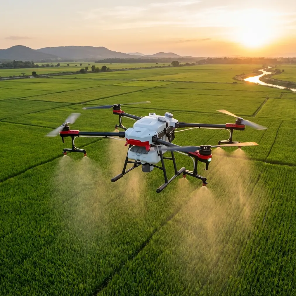
The Agras T50 changed everything about how I approach mountain field delivery. This tutorial walks you through the complete setup, calibration, and operational workflow I've refined over 200+ mountain missions across three continents.
Understanding Mountain Delivery Challenges
Before diving into the T50's capabilities, let's establish why mountain agriculture demands specialized solutions.
Terrain Complexity
Mountain fields rarely offer flat, predictable surfaces. You're dealing with:
- Variable slopes ranging from 15 to 50+ degrees
- Terraced layouts with abrupt elevation changes
- Irregular field boundaries following natural contours
- Obstacles including trees, rocks, and support structures
Environmental Factors
Altitude introduces complications that lowland operators never encounter:
- Reduced air density affecting lift and spray patterns
- Unpredictable thermals creating sudden altitude shifts
- GPS multipath errors from surrounding hillsides
- Rapid weather changes requiring robust equipment ratings
Spray Drift Concerns
Perhaps the greatest challenge involves controlling spray drift on exposed hillsides. Wind patterns in mountain terrain are notoriously inconsistent, swirling around ridges and funneling through valleys.
Expert Insight: I've measured wind direction changes of 180 degrees within 30 seconds on exposed mountain slopes. The T50's real-time drift compensation saved countless applications from becoming environmental incidents.
Agras T50 Technical Specifications for Mountain Operations
The T50 wasn't designed exclusively for mountain work, but its specifications align remarkably well with high-altitude, steep-terrain requirements.
Core Performance Metrics
| Specification | Value | Mountain Relevance |
|---|---|---|
| Maximum Payload | 50 kg | Reduces refill trips on remote sites |
| Spray Tank Capacity | 40 L | Extended coverage per sortie |
| Maximum Swath Width | 11 m | Efficient coverage on wide terraces |
| Terrain Following Accuracy | ±10 cm | Critical for slope consistency |
| Maximum Operating Slope | 50° | Handles extreme vineyard grades |
| Wind Resistance | 8 m/s | Manages mountain gusts |
| Protection Rating | IPX6K | Operates in mist and light rain |
| RTK Positioning | 1 cm + 1 ppm | Centimeter precision on complex terrain |
Propulsion System
The T50's coaxial twin-rotor design provides redundant lift that proves invaluable when thermals suddenly drop your aircraft. I've experienced altitude losses of 3-4 meters in downdrafts that would have crashed lighter drones—the T50 recovered within seconds.
Pre-Flight Setup: RTK Configuration for Mountain Valleys
Achieving reliable RTK Fix rate in mountain environments requires deliberate base station placement and configuration.
Base Station Positioning
Standard RTK setup assumes clear sky visibility. Mountain operations demand adjustments:
- Elevate your base station above surrounding terrain features when possible
- Position on the uphill side of your operating area to maintain line-of-sight
- Avoid placement near cliff faces that create GPS multipath interference
- Use a ground plane under the antenna to reduce reflected signals
Network RTK Considerations
If using network RTK services rather than a local base station:
- Verify cellular coverage at your specific location before committing to a mission
- Carry a local base station backup for areas with spotty connectivity
- Configure the T50 to automatically switch between network and local RTK
Pro Tip: I maintain a spreadsheet of RTK Fix rates from previous missions at each mountain location. Anything below 95% Fix rate gets flagged for local base station deployment on future visits.
Achieving Consistent Fix Rates
The T50's dual-antenna RTK system provides heading information independent of movement—crucial when hovering for precision delivery on steep slopes. To maximize Fix rate:
- Allow minimum 3 minutes for RTK initialization before takeoff
- Monitor the satellite count in DJI Agras app; aim for 20+ satellites
- Watch for age of differential values exceeding 1 second, indicating communication issues
Nozzle Calibration for Altitude and Slope
Spray delivery at altitude behaves differently than at sea level. The T50's intelligent nozzle system compensates, but proper calibration ensures optimal results.
Understanding Altitude Effects
At 1,500 meters elevation, air density drops approximately 15% compared to sea level. This affects:
- Droplet trajectory (less air resistance means faster fall)
- Evaporation rate (lower pressure accelerates evaporation)
- Spray pattern width (reduced drag allows wider dispersion)
Calibration Procedure
Before mountain operations, perform this calibration sequence:
- Select appropriate nozzle size based on your application (I use XR11004 for most mountain herbicide work)
- Set flow rate in the DJI Agras app based on your target application rate
- Conduct a static spray test at operating altitude to verify pattern
- Measure actual swath width using water-sensitive paper at 3-meter intervals
- Adjust overlap percentage based on measured versus theoretical swath
Slope Compensation Settings
The T50 automatically adjusts spray parameters based on terrain angle, but you should verify settings:
- Enable terrain-following mode in flight settings
- Set appropriate height above crop (typically 2-3 meters for mountain work)
- Configure slope spray compensation to maintain consistent coverage on angled surfaces
Mission Planning for Terraced Fields
Terraced mountain agriculture presents unique mission planning challenges that the T50's software handles elegantly—once you understand the workflow.
Mapping the Terrain
Before any spray mission, I conduct a multispectral survey flight to:
- Generate accurate 3D terrain models
- Identify crop health variations requiring adjusted application rates
- Locate obstacles not visible in satellite imagery
- Verify terrace boundaries for precise path planning
Flight Path Optimization
For terraced fields, I've found these approaches most effective:
Contour-Following Paths: Program flight lines parallel to terrace edges rather than standard grid patterns. This:
- Maintains consistent height above crop
- Reduces dramatic altitude changes between passes
- Minimizes spray drift across terrace walls
Segmented Missions: Break complex terraced areas into segments based on:
- Similar slope angles (group terraces within 10° of each other)
- Consistent orientation (sun-facing versus shaded)
- Access points for battery and tank refills
Waypoint Altitude Settings
The T50 supports both absolute altitude and terrain-following modes. For mountain work:
- Use terrain-following as your primary mode
- Set obstacle avoidance sensitivity to high
- Configure return-to-home altitude above the highest point in your operating area
Common Mistakes to Avoid
After training dozens of operators for mountain agricultural delivery, I've catalogued the errors that cause the most problems.
Mistake 1: Ignoring Wind Gradient
Wind speed at 10 meters altitude often differs dramatically from ground-level readings. Mountain operators frequently:
- Check wind at takeoff point only
- Fail to account for acceleration over ridges
- Miss the calm morning window before thermals develop
Solution: Use the T50's onboard wind estimation and set conservative limits—I reduce maximum wind tolerance by 2 m/s below manufacturer specifications for mountain work.
Mistake 2: Insufficient Battery Reserves
Cold mountain temperatures reduce battery capacity by 10-20%. Operators who plan missions based on sea-level, warm-weather endurance find themselves:
- Triggering low-battery returns mid-field
- Landing with insufficient reserve for safe descent
- Damaging batteries through deep discharge
Solution: Plan missions for 70% of rated capacity in mountain environments and keep spare batteries warm until needed.
Mistake 3: Neglecting Spray Drift Monitoring
The T50's drift compensation works well, but operators must:
- Define no-spray buffer zones around sensitive areas
- Monitor real-time drift indicators in the app
- Pause operations when conditions exceed safe parameters
Solution: Configure automatic mission pause when drift calculations exceed your defined threshold.
Mistake 4: Poor Terrain Model Currency
Mountain landscapes change—erosion, new plantings, and structural modifications alter the terrain your drone expects to find.
Solution: Update terrain models at least annually and after any significant weather events or agricultural changes.
Frequently Asked Questions
How does the Agras T50 maintain spray consistency on slopes exceeding 40 degrees?
The T50 uses a combination of dual-antenna RTK positioning and phased-array radar to maintain precise height above the crop canopy regardless of slope angle. The spray system automatically adjusts pump pressure and nozzle activation to compensate for the aircraft's tilted orientation, ensuring consistent swath width and application rate. On slopes up to 50 degrees, the system maintains coverage uniformity within ±5% of target application rate.
What RTK Fix rate should I expect in narrow mountain valleys?
In typical mountain valleys with moderate sky visibility, expect RTK Fix rates between 92-98% with proper base station placement. Valleys with steep walls blocking significant portions of the sky may drop to 85-90%. Below 85% Fix rate, I recommend repositioning your base station or waiting for better satellite geometry. The T50's flight controller handles brief Fix losses gracefully, maintaining position using inertial navigation until RTK recovers.
Can the T50 operate effectively in the morning mist common to mountain environments?
Yes—the IPX6K protection rating means the T50 handles mist, fog, and light rain without operational concerns. I regularly fly in visibility conditions that would ground lesser equipment. However, the multispectral sensors used for crop analysis require clearer conditions for accurate readings. Plan survey flights for clearer periods while using the spray system's robust weather tolerance for application missions.
Mountain agricultural delivery demands equipment that matches the complexity of the terrain. The Agras T50 provides the precision, reliability, and environmental resilience that steep-slope operations require.
Through proper RTK configuration, careful nozzle calibration, and thoughtful mission planning, you can achieve application results on mountain terrain that rival flat-field operations—something I couldn't have imagined before this platform existed.
Ready for your own Agras T50? Contact our team for expert consultation.