Agras T50 in the Mountains: A Field Report on Seeing More
Agras T50 in the Mountains: A Field Report on Seeing More Than a Spray Mission
META: A field report on how Agras T50 workflows, sensing discipline, camera stability concepts, and training methods translate to mountain wildlife observation and terrain-aware agricultural operations.
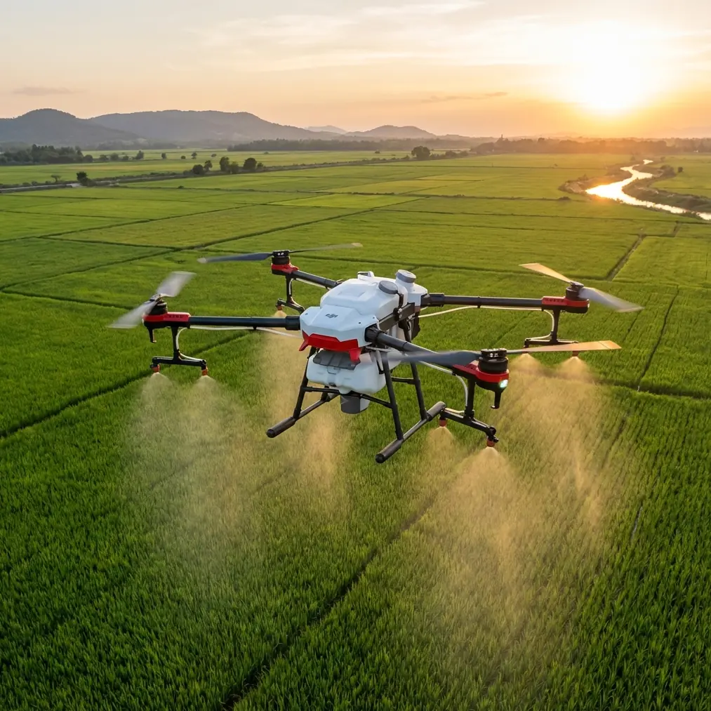
The most interesting thing about the Agras T50 is not that it is powerful. Plenty of aircraft are powerful. What matters is how a machine built for demanding farm work behaves when the environment stops being forgiving.
Mountain terrain does that quickly. Slopes distort depth perception. Tree lines interrupt approach paths. Wind can be calm at shoulder height and unsettled a few meters above. If your mission involves observing wildlife around upland orchards, terraces, grazing margins, or conservation buffer zones, the aircraft has to do more than carry liquid efficiently. It has to hold a stable, predictable line while the operator interprets a complicated scene.
That is why the right way to discuss the Agras T50 for this reader is not as a generic crop drone. It is as a field platform whose value depends on sensing, route discipline, image clarity, and controlled operations in constrained space.
Why a mountain wildlife scenario changes the conversation
Readers searching for Agras T50 usually want payload, efficiency, and broad-acre productivity. Those are valid concerns. But the mountain user trying to capture wildlife activity near agricultural land is dealing with a hybrid mission. Part of the day may involve crop protection planning or site assessment. Another part may involve documenting animal movement near water channels, edge habitat, or mountain fruit blocks.
In that setting, aircraft behavior matters as much as output volume.
A useful reference point comes from an educational drone maze exercise built around autonomous navigation. The test environment is a 3 x 4 maze of 12 cells, each cell 60 cm by 60 cm, for an overall space of 240 cm x 180 cm x 120 cm. That sounds tiny compared with an agricultural flight area, but the lesson scales. In the maze, the drone must move from start to finish while respecting boundaries, using TOF obstacle avoidance, camera sensing, and visual positioning cues. The point is not the maze itself. The point is that disciplined autonomous flight begins with understanding confinement, surface texture, and route planning.
Mountain operations feel spacious until they do not. A ridgeline, a stand of taller trees, a netted orchard section, or a utility corridor can compress your usable airspace just as effectively as a training maze. If an operator has never learned to think in terms of constrained geometry, the mission degrades fast. The Agras T50 becomes much more valuable when it is flown by someone who understands corridor logic, obstacle margins, and precise entry-exit planning.
Stability is not just a filming concern
One overlooked insight from VR drone design is directly relevant here: camera quality, high resolution, and image stabilization determine whether airborne viewing is actually usable. That observation came from immersive drone use, but the principle carries over cleanly to mountain wildlife work.
When you are trying to identify movement near rock outcrops or watch the edge between crop rows and scrub cover, a shaky image wastes time and invites mistakes. High-resolution aerial imagery is not merely pleasing. It helps separate a moving animal from wind-driven vegetation, reveals footpaths or bedding zones near field perimeters, and improves confidence when reviewing operations after the flight.
This matters operationally because the T50 is often discussed only in terms of application width, flow, or throughput. Yet in mixed missions, stable visual feedback is what lets the operator adapt. You may decide to avoid a certain slope because bird activity is higher than expected. You may revise a swath boundary because hoof traffic has softened the soil at a terrace edge. A cleaner view changes decisions in real time.
For that reason, one of the smartest upgrades I have seen in the field was not something glamorous. It was a third-party sun hood and high-bright monitor mount for the remote display, paired with a ruggedized carry setup. In mountain light, glare can reduce the practical value of the live view even when the onboard imaging is good. Improving visibility at the controller level can make the difference between a hesitant operator and a precise one. If you are building a T50 field kit around wildlife-aware observation, this type of accessory earns its place.
The hidden value of training like a maze pilot
The educational maze reference includes another detail worth dwelling on: the floor uses a dark map with many small dots for visual positioning, though other textured surfaces can also work. That tells us something simple but powerful. Autonomous performance depends on what the aircraft can reliably perceive.
In mountains, ground texture changes constantly. Bare soil, mulched orchard lanes, grass, stone, wet patches, and shadow bands all alter sensor confidence. Operators who understand visual localization tend to make better route choices and maintain stronger margins. They do not assume the aircraft “just knows” where it is. They think in terms of how sensing quality changes across the mission.
That mindset also sharpens the importance of RTK fix rate and centimeter precision. Even when your primary purpose is agricultural, mountain-edge work benefits from precise repeatability. If wildlife is entering a field from the same saddle or drainage line each dawn, a repeatable route lets you compare conditions from one mission to the next. If you are trying to manage spray drift risk along habitat boundaries, precise positioning helps you hold the line where application stops and conservation space begins.
This is where many operators oversimplify the T50. They focus on width and speed, but mountain work often rewards repeatability over aggression. A slightly slower mission with stronger positional confidence is usually the professional choice.
Spray drift is a wildlife issue, not just an agronomy issue
The phrase “capturing wildlife” can sound like a pure observation task, but in agricultural mountainscapes, wildlife and application practice are tied together. If deer, birds, pollinators, or smaller mammals are using field edges, then spray drift is not a technical side note. It is a habitat management concern.
That makes nozzle calibration more than maintenance. Calibration affects droplet behavior, edge definition, and the quality of your environmental stewardship. On a mountain slope, local airflow can curl and lift unexpectedly. A misjudged setup can push material beyond the intended zone, especially near breaks in vegetation or exposed contours.
A disciplined T50 workflow therefore starts before the motors spool up:
- confirm nozzle condition and calibration;
- verify route geometry along sensitive boundaries;
- check wind not only at takeoff but at working altitude;
- evaluate whether terrain funnels air through saddles or cuts;
- define a no-spray margin near observed wildlife congregation points.
None of that is glamorous. All of it is professional.
The older model-aircraft training literature offers a blunt but still relevant lesson: takeoff and landing become risky when speed is too low or too high, and the pilot should not fly without a plan. It also warns that low-level calm does not guarantee calm conditions aloft, and suggests avoiding sites with tall trees or poor escape space. Those are fixed-wing training notes, but the operational logic transfers. Mountain drone missions fail when crews confuse a quiet launch point with a safe air environment.
The Agras T50 gives you capability. It does not remove the need for judgment.
What a real field workflow looks like
For wildlife-aware mountain work, I prefer a three-layer workflow rather than a single “mission type.”
1. Recon layer
Start with a non-invasive visual pass to understand movement, terrain breaks, canopy gaps, and light conditions. Here, image clarity and stabilization matter the most. If the live feed is hard to read, you are collecting noise instead of insight.
2. Precision planning layer
This is where RTK fix rate, route logic, and exclusion zones take center stage. If a game trail crosses the lower edge of a terrace block, mark it. If a water trough attracts activity, work your route to reduce disturbance. If the objective includes crop treatment, map the swath so the line between productive area and habitat edge is deliberate, not approximate.
3. Application or monitoring layer
Only after the first two layers are solid should you commit to the operational task, whether that is spraying, stand assessment, crop vigor review, or repeated monitoring. If you use a multispectral workflow elsewhere on the property, that data can add context by highlighting plant stress near wildlife pressure zones, though the T50 conversation here is really about execution discipline more than sensor stacking.
Why the T50 suits operators who think like systems people
The Agras T50 is at its best when treated as one part of a larger field system. The aircraft, the sensing environment, the route plan, the edge conditions, and the human operator all matter.
That is why the maze-training analogy is unexpectedly useful. In the training scenario, the drone must move from a defined start cell to a defined end cell, with wall restrictions and hidden task points embedded in the course. In mountain work, your “walls” may be tree belts, steep drops, fence lines, rocky shelves, or habitat exclusions. Your “hidden tasks” are the things an inexperienced crew misses: glare on the display, inconsistent surface texture affecting visual positioning, a wind stream crossing the ridge, or animals using a margin that looked empty from the ground.
A good T50 operator sees those hidden tasks early.
Field kit details that actually matter
If your use case combines agriculture and mountain wildlife observation, build the kit around reliability rather than novelty:
- a display setup that remains readable in harsh light;
- a secure transport case instead of a loose bag;
- spare field fasteners and basic hand tools;
- battery discipline and preflight checklists;
- a route-planning routine that includes terrain, not just boundaries.
That last point sounds basic, but basic failures remain common. The fixed-wing training reference spends surprising time on preflight details like checking control surfaces, carrying proper tools, and not improvising your transport setup. That is because small negligence cascades. The same is true with a T50. A rushed launch from a cluttered mountain layby is rarely a sign of experience.
If you are trying to refine a mountain-ready Agras T50 setup, including controller visibility accessories and route-planning habits that support observation as well as field work, this is the sort of scenario where a direct technical exchange can save wasted trial time: message a field specialist here.
The operational significance of image quality in non-cinematic work
Let’s return to the VR drone reference one more time, because it surfaces a truth the agricultural sector sometimes understates. Higher-resolution cameras and advanced stabilization reduce the effect of vibration and improve scene readability. In the mountain environment, that has practical consequences:
- better distinction between wildlife movement and foliage motion;
- more confident obstacle assessment near branches and slope transitions;
- cleaner documentation for repeated route comparison;
- less pilot fatigue from trying to interpret jittery live views.
That is not entertainment value. That is operational efficiency.
Final assessment
If your interest in the Agras T50 comes from mountain wildlife capture around agricultural land, the aircraft should be evaluated through a narrower and more demanding lens than “How much area can it cover?”
Ask instead:
Can it support repeatable route execution with centimeter-level confidence when terrain complicates line-of-sight assumptions?
Can the operator maintain enough visual clarity to identify movement and edge conditions in changing light?
Can the mission plan reduce spray drift risk near habitat boundaries?
Can the crew work with the discipline of a constrained-space navigator rather than a wide-open-field optimist?
Those are the questions that separate generic use from expert use.
The Agras T50 belongs in this conversation because serious mountain operations are never just about payload. They are about control, perception, and the maturity to plan each pass as if the environment will expose every shortcut. In my view, that is exactly where the aircraft becomes most interesting.
Ready for your own Agras T50? Contact our team for expert consultation.