Agras T50 for Remote Venue Capture: What Actually Matters
Agras T50 for Remote Venue Capture: What Actually Matters in the Field
META: A field-driven case study on using the Agras T50 for remote venue capture, with practical insight on navigation logic, obstacle sensing, route consistency, spray control, and why disciplined flight fundamentals matter.
Remote venue work sounds simple until you leave the road.
A site may look straightforward on a map: a mountain resort under development, a riverside event ground, a large ecological park, or a tourism property that needs regular aerial documentation before opening season. Then you arrive and discover the real constraints. Uneven terrain. Sparse landmarks. Gusts funneled through valleys. Temporary structures. Signal interruptions. Tight operating windows. One pass that is too wide or too low can ruin data consistency, and one unstable turn can waste a sortie.
That is where the Agras T50 becomes interesting—not because it is merely a large agricultural platform, but because some of the same design priorities that matter in precision field operations also translate well to repeatable remote venue capture. The key is understanding which technical behaviors matter in practice.
A remote-site lesson from low-altitude tourism
A recent low-altitude tourism story out of Zhengzhou offers a useful reference point. During the May 1 to May 5 holiday period, low-altitude sightseeing flights centered around Shangjie Airport and extending to destinations such as Yuntaishan, Jigongshan, and Baoquan handled more than 2,700 passenger visits in just 5 days.
That number matters for one reason: it shows there is real operational demand for aerial access to scenic, distributed, terrain-sensitive destinations. Remote venues are no longer edge cases. They are active commercial spaces. Whether the mission is tourism promotion, venue progress capture, landscaping documentation, infrastructure monitoring, or pre-event site review, operators increasingly need aircraft that can work far from ideal launch conditions while maintaining route discipline and predictable results.
The T50 sits at an unusual intersection here. It was built for productivity, but its value in remote venue environments often comes from stability, navigation confidence, and repeatability rather than raw payload alone.
The real challenge is not “getting a drone in the air”
Most discussions around aircraft choice get stuck at broad claims: more power, smarter sensors, stronger frame. Those phrases do not help much when you are standing at a remote venue trying to capture usable, consistent material.
What matters is this:
- Can the aircraft hold a reliable line over irregular ground?
- Can it maintain repeatable spacing between passes?
- Can obstacle awareness reduce surprises around trees, poles, temporary rigging, or terrain transitions?
- Can the platform support stable route execution when visual references are poor?
- Can the operator trust the aircraft’s logic enough to focus on mission quality rather than constant correction?
To answer that, it helps to step back from product marketing and look at the underlying flight principles reflected in the reference materials.
Why flight control architecture matters more than spec-sheet theatrics
One of the reference documents explains the flight control system in very plain terms: the flight controller is the aircraft’s brain, responsible for the full chain of operation from takeoff to mission execution to return. It highlights the hardware stack behind that logic, including a three-axis gyroscope, acceleration sensors, position sensors, and a barometric altimeter, all working with software control algorithms. It also describes how the aircraft uses sensor data to regulate attitude, altitude, and position, and how navigation relies on coordinate, speed, attitude, and obstacle information.
That sounds elementary until you relate it to remote venue capture.
When you are documenting a site tucked into variable terrain, stable flight is not just about aesthetics. It affects overlap consistency, framing repeatability, safety margins, and the operator’s mental workload. If the aircraft can continuously regulate tilt, height, and spatial position with confidence, you are less likely to see route wobble, inconsistent lateral spacing, or drift-induced gaps in your coverage pattern.
This is also where competitor comparisons often become shallow. Many platforms claim autonomous routing. Fewer inspire confidence when the terrain starts to force constant tiny corrections. The difference is not always visible in a brochure. It shows up in how often the pilot needs to intervene, how cleanly the aircraft settles near a point, and whether the route flown at noon resembles the route flown at 4 p.m.
For T50 operators working remote venues, RTK fix rate and centimeter precision are not abstract buzzwords. They are the difference between “roughly the same pass” and “the same pass in a way that supports reliable comparison over time.”
Obstacle sensing is not a luxury in venue work
The same flight-control reference also mentions a navigation layer built around visual sensing and TOF distance sensing. Specifically, it notes downward and forward sensing, along with TOF-based height and ranging used to form an obstacle-avoidance system that gives the aircraft the ability to identify obstacles and support autonomous navigation.
Operationally, that matters a lot more than people think.
Remote venues are full of semi-permanent surprises: cable runs for temporary power, scaffold edges, decorative installations, fencing changes, tent structures, tree canopies, parked machinery, even slope breaks that distort depth perception. On a manual platform with weak environmental awareness, the pilot spends much of the mission compensating for uncertainty. With a stronger sensing stack, the aircraft handles more of the low-level situational burden.
For the T50, this matters in two ways.
First, obstacle awareness supports safer, more confident route planning around uneven or partially obstructed spaces. Second, it protects consistency. An operator who trusts the aircraft’s sensing and height behavior is less likely to overcompensate with exaggerated separation distances that compromise capture efficiency.
That becomes especially relevant in remote environments where venue managers often need repeat documentation from the same launch zone. If your route geometry changes too much from flight to flight because you do not trust the machine near real-world obstacles, your archive loses value.
The hidden crossover from aerobatic training to commercial discipline
At first glance, a reference about radio-controlled aerobatics seems unrelated to a T50. It is not.
The training text on the reverse Cuban eight breaks down a maneuver into clear stages: pull into a 45° climb, roll to inverted, then recover smoothly. It emphasizes something that professional operators in commercial drone work often underestimate—timing, symmetry, and the exact starting point of the maneuver. It even notes that preparatory exercises before the full maneuver are designed so the action remains symmetrical on both sides in front of the pilot.
That is a useful mental model for remote venue capture.
Commercial missions do not require aerobatics, obviously. But they do demand the same discipline of entry point, line establishment, and repeatable geometry. In the aerobatic document, the 45° line is not casual; it must be built accurately, with attention to control input speed and amplitude. In venue capture, the equivalent is your first line, your turn initiation point, your swath width, your altitude transition, and your return alignment.
Agras T50 operators who perform best in difficult terrain usually do one thing differently from average operators: they treat every route like a controlled figure rather than a loose exploration. They establish the line cleanly. They enter turns consistently. They maintain planned spacing. They monitor drift and make corrections early, not late.
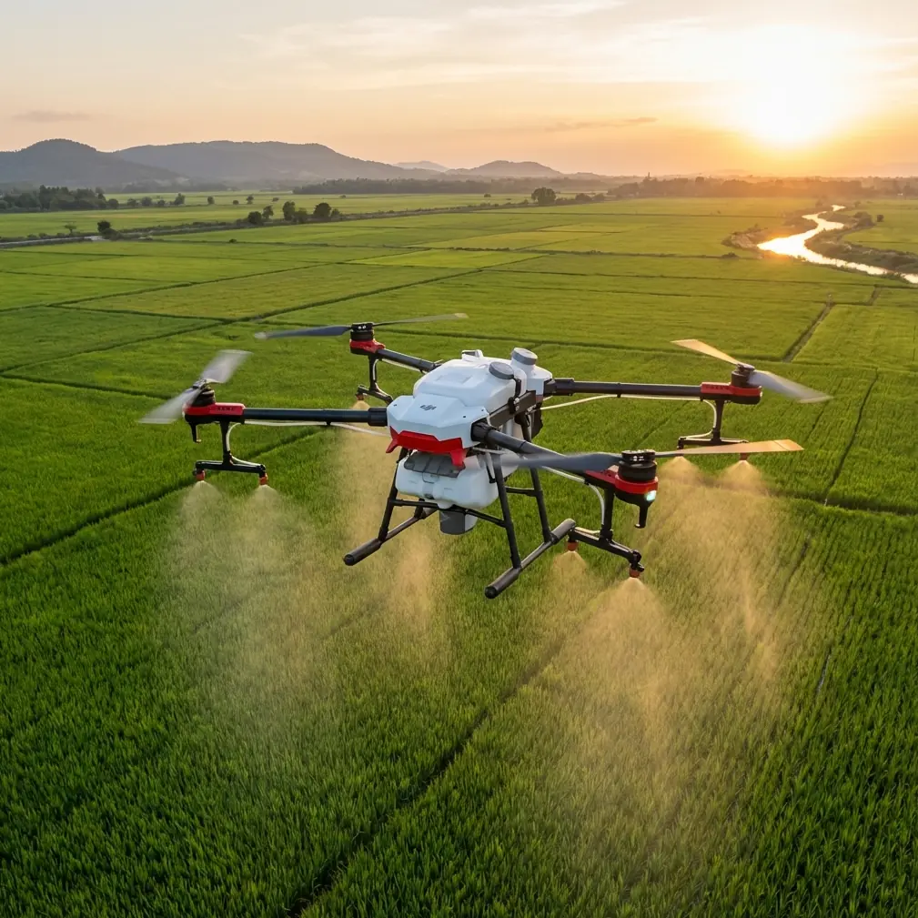
That matters even more if your mission combines visual documentation with application-style pattern work, such as dust suppression, vegetation treatment around a tourism property, or landscape maintenance. Spray drift becomes a serious concern in scenic or visitor-facing spaces. A sloppy turn or unstable line is not just inefficient; it can alter droplet placement, widen the effective treatment area, and create avoidable contamination near paths, structures, or water features.
Case study: using the T50 at a mountain venue perimeter
Consider a fictional but realistic case.
A remote mountain venue is preparing for a seasonal opening. The property includes a main event lawn, access roads, hillside landscaping, a parking terrace, and a belt of vegetation that requires routine treatment and inspection. The management team wants two things from one aircraft program: consistent aerial capture of site progress and efficient coverage of landscaped perimeters where ground equipment struggles.
This is where the T50’s strengths start to stack.
The first task is route repeatability. Because the site includes sloped surfaces and broken topography, a platform with weak positioning behavior will produce inconsistent passes and uneven spacing. Strong navigation logic, assisted by RTK-based centimeter precision when available, improves the odds that one survey or capture mission will meaningfully match the next.
The second task is environmental awareness. The venue has decorative archways, lighting poles, tree clusters, and changing temporary structures ahead of opening events. Forward and downward sensing, plus TOF-based obstacle logic, reduce the risk of route interruption or improvised manual evasions that break mission consistency.
The third task is treatment quality in landscaped zones. Here, nozzle calibration and swath width become practical, not theoretical. If the operator does not calibrate correctly for the target vegetation and local wind behavior, spray drift can affect guest-facing areas. The T50’s value is not simply that it can carry and cover; it is that a disciplined operator can pair route repeatability with calibrated application behavior to work precisely around sensitive venue edges.
A competitor may promise similar area coverage. But in remote venue work, that is not the decisive metric. The better aircraft is usually the one that holds the plan with less drama.
Why IP rating and field durability deserve more attention
Remote venues are often messy operating environments. Dust from unfinished roads. Moisture near irrigation systems. Mud at improvised launch points. Light rain risk during narrow work windows.
That is why IPX6K-level durability is not a decorative spec in this category. For a T50 deployed across remote hospitality, eco-tourism, or venue-preparation operations, ruggedization reduces the number of conditions that force you to delay, relocate, or overprotect the aircraft. Reliability in rough field handling matters because remote jobs do not always offer clean benches, sheltered prep areas, or easy return logistics.
This is another area where the T50 often stands apart from lighter, more delicate alternatives. Some competing drones are pleasant in ideal conditions and frustrating in actual site prep environments. The T50 is better understood as a working machine first.
What experienced operators do differently with the T50
The strongest T50 results usually come from process, not heroics.
They confirm RTK fix rate before committing to a repeatable route. They set swath width based on real conditions rather than maximum theory. They calibrate nozzles with the target vegetation, weather, and drift risk in mind. They build routes around terrain and obstacle logic, not just map convenience. They keep turns deliberate and symmetrical, much like a well-practiced flight figure. They use the aircraft’s sensing and control architecture to reduce workload, then spend that saved attention on mission quality.
That philosophy is straight out of the references, even though the references come from different corners of aviation. One explains that the aircraft’s brain is built on layered sensing and control. Another shows that accurate outcomes depend on entry timing, geometry, and disciplined execution. Put together, they describe the real operating mindset behind successful T50 work.
The takeaway for remote venue teams
If your job is capturing or maintaining venues in remote areas, the Agras T50 should not be judged as just a large agricultural drone. Its real advantage is that it brings industrial-grade control logic, navigation support, and field toughness into missions where route consistency and operational confidence are usually harder to achieve than raw lift.
That is why the Zhengzhou tourism data is more than a travel headline. More than 2,700 people used low-altitude sightseeing services in 5 days around scenic destinations. Demand for aerial access around distributed, terrain-sensitive venues is not hypothetical. The aircraft supporting those environments must be able to work where the ground setup is imperfect and the flight path still needs to be precise.
If you are designing a T50 workflow for remote venue capture, landscaping treatment, or mixed documentation missions, start with the fundamentals that actually affect the result: navigation integrity, obstacle sensing, nozzle calibration, spray drift control, swath discipline, and repeatable line entry. That is where the aircraft earns its keep.
If you want to discuss route design or field setup for a remote venue project, you can message Marcus directly here.
Ready for your own Agras T50? Contact our team for expert consultation.