Capturing Mountain Solar Farms with the Agras T50 When Condi
Capturing Mountain Solar Farms with the Agras T50 When Conditions Shift Mid-Flight
META: A field-focused look at using the Agras T50 around mountain solar farms, with lessons on weather shifts, precision flight, operator training, and why new UAV exam pilot programs matter.
Mountain solar sites look tidy on a map. In the field, they rarely are.
The access roads are narrow, the wind behaves differently on each ridge, and the layout tends to stretch across uneven ground where visual line management becomes harder than expected. Add a weather change halfway through a mission and the gap between a capable aircraft and a dependable operation becomes obvious very quickly.
That is where the Agras T50 becomes interesting, not as a generic “big drone,” but as a platform that can make difficult civilian work more repeatable when the mission is carefully planned and the crew is properly trained. For teams tasked with capturing imagery and site records around solar farms in mountain terrain, the real issue is not whether a drone can fly. Plenty can. The issue is whether it can hold precise lines, adapt to changing conditions, and support an operator who understands both aircraft behavior and regulated flight practice.
A recent development in Northeast China deserves attention here for exactly that reason. The Civil Aviation Administration’s Northeast regional authority announced three pilot units for independent small and medium UAV license examination sites. On the surface, that sounds like a licensing story rather than an operations story. In reality, it goes straight to the heart of whether aircraft like the T50 can be used well in demanding commercial environments.
The real problem at mountain solar farms
A mountain solar farm is an awkward place to collect usable aerial data. Panels create repeating visual patterns that can confuse manual orientation. Slopes distort altitude perception. Wind can be calm near the launch point and noticeably stronger over the next row of terrain. And because the site often spans multiple elevations, the aircraft is constantly negotiating changing ground clearance.
The challenge gets sharper when weather turns during the job.
I have seen missions begin with stable air and enough visibility to work cleanly around string inverters, access corridors, and panel blocks, then shift within minutes as cloud cover thickened and ridge wind started moving laterally across the site. Under those conditions, what matters is not marketing language. What matters is control confidence, route discipline, and the aircraft’s ability to maintain stable positioning with centimeter-level precision when RTK conditions are good.
That last point matters more than many crews admit. On a mountain solar site, your RTK fix rate is not just a technical stat. It shapes the consistency of your passes, your overlap quality, and the amount of correction work required afterward. If the aircraft is drifting or the positioning solution is unstable, the operator ends up spending more time managing the aircraft than observing the site. That is the opposite of what you want when the weather window is tightening.
Why the Agras T50 fits this kind of site work
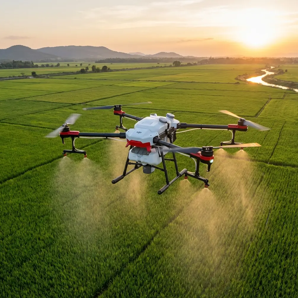
The T50 is commonly associated with agricultural operations, and fairly so. But some of the same traits that matter in field application work also matter when you are navigating utility-scale infrastructure on broken terrain.
Take swath width and route discipline. In agricultural spraying, swath consistency directly affects coverage. At a solar farm, that same operational mindset translates into more predictable line spacing for image capture and inspection-oriented flight paths. You are not just flying over a site; you are building a pattern the team can trust and repeat. On steep or irregular ground, that repeatability can be the difference between a usable dataset and a patchwork of gaps, duplicated passes, and questionable edges.
Then there is environmental resilience. The mention of IPX6K is not trivial in this scenario. Mountain operations do not always fail because of heavy rain. Often they get complicated by mist, blown moisture, residue, dust from service roads, or a quick shift from dry air to damp airflow moving over a slope. Equipment that tolerates harsh working conditions gives operators more room to focus on safe decision-making instead of worrying about every environmental fluctuation.
Even details like nozzle calibration and spray drift, though rooted in application work, reveal something useful about the T50’s operational profile. A platform designed around controlled output and drift awareness is, by definition, a platform built for disciplined environmental interaction. Around solar infrastructure, that matters because the same sensitivity to wind behavior helps crews understand how air movement may affect route stability, obstacle margins, and data consistency. In other words, if you train on a system where drift and calibration are serious operational variables, you are more likely to bring the right habits into non-spraying missions as well.
The weather shift that changes the mission
Here is the moment that usually separates smooth theory from actual field work.
The crew launches in stable morning conditions. The aircraft is tracking well. RTK lock is strong. The first section of the site is captured efficiently, and the route geometry looks clean. Then the mountain does what mountains do. A crosswind begins to push from one shoulder of the site. Light changes. The air becomes uneven. The aircraft starts seeing a different environment over the far end of the array than it did near the takeoff point.
With the T50, the advantage is not that it magically erases weather. No responsible operator should think that way. The advantage is that the aircraft gives the pilot a platform capable of maintaining disciplined flight when the environment begins to degrade, assuming the operator responds correctly.
That “assuming” is everything.
A strong machine in weak hands creates weak outcomes. Which brings us back to the licensing pilot program announced by the Northeast regional authority. The fact that three separate pilot units were designated for independent UAV license examination site trials is operationally significant because it points toward a more distributed and structured pipeline for evaluating small and medium drone operators. That matters for aircraft such as the Agras T50 because these are not casual hobby platforms. They are professional tools used in real commercial settings where terrain, weather, and mission complexity can stack quickly.
More exam capacity and trial-based testing infrastructure can improve access to standardized evaluation. For mountain solar work, that means a better chance of seeing operators who are not merely familiar with controls, but who have been assessed in a more formal framework tied to actual licensing practice. If you are deploying a T50 near expensive energy assets on uneven terrain, that kind of competence is not administrative overhead. It is part of mission quality.
Why operator qualification matters more than people think
There is a persistent mistake in commercial drone operations: teams over-focus on hardware and under-invest in operator maturity.
The Northeast announcement is narrow in wording. It concerns pilot units tasked with carrying out independent examination site trial work for small and medium UAV licenses. But that narrow detail has a broad downstream effect. It signals institutional attention to who gets evaluated, how they are evaluated, and where they can do so. For T50 operators working in specialized environments, that helps elevate the entire operational baseline.
That has direct consequences on a mountain solar mission.
A trained operator is more likely to anticipate how slope geometry affects flight lines. More likely to watch for changing wind direction at array edges. More likely to monitor whether a strong RTK fix is being maintained before trusting tightly structured routes. More likely to know when to pause the mission rather than forcing completion through degraded conditions.
And when the weather changes mid-flight, that judgment can save the day.
The correct response is rarely dramatic. It might mean shortening the working section, adjusting route orientation relative to the new wind, reassessing visual conditions around panel rows, and tightening margins around terrain transitions. On some days, it means stopping entirely. Good licensing and evaluation culture does not just teach a person to operate. It teaches them not to bluff.
The T50 in a problem-solution workflow
If I were structuring a mountain solar capture job around the Agras T50, I would think in a simple problem-solution sequence.
Problem 1: Uneven terrain disrupts consistent capture
Mountain sites create altitude and spacing inconsistencies that degrade image quality and route repeatability.
Solution: Use the T50’s precision-oriented flight characteristics to maintain controlled, repeatable paths, with special attention to centimeter precision under solid RTK conditions. This reduces the amount of inconsistent coverage caused by slope-induced altitude error and operator overcorrection.
Problem 2: Mid-flight weather changes alter aircraft behavior
A route that works in calm air may become inefficient or risky when crosswinds begin moving across the array.
Solution: Treat wind response as a live operational factor, not a background condition. The T50’s stable working profile helps, but the operator must continuously assess route orientation, drift tendency, and whether the current RTK fix rate still supports the planned pass structure.
Problem 3: Harsh site conditions stress equipment
Dust, moisture, and variable mountain weather create wear and reliability concerns.
Solution: A platform with IPX6K-level protection is better suited to difficult field environments, especially when the site demands repeated deployment rather than occasional use.
Problem 4: Technical capability outpaces pilot readiness
Teams adopt advanced UAVs without matching them to licensed, assessed operators.
Solution: Pay attention to developments like the Northeast region’s three independent exam-site pilot units. This kind of licensing infrastructure supports stronger operator validation, which directly affects performance in complex commercial jobs.
A note on sensors and site strategy
The T50 discussion often intersects with terms like multispectral, and while not every mountain solar capture mission requires that workflow, the broader lesson is that data quality starts before the aircraft leaves the ground. Sensor selection, line planning, terrain awareness, and environmental timing all matter.
What I would stress to any team is this: the aircraft does not rescue a weak capture strategy.
If your route ignores slope transitions, if your launch timing does not account for mountain weather behavior, or if your operator is trying to compensate for poor planning in the air, even a capable platform will only deliver mediocre results. The T50 gives you a robust operational base. It does not replace judgment.
For teams working through those details, it can help to compare route logic, terrain assumptions, and field setup with someone who has dealt with similar mountain sites before. If that is useful, you can message here for field-planning discussion.
What this means for the Agras T50 audience right now
The most interesting part of the reference news is not bureaucratic. It is practical.
When a regional civil aviation authority formally announces three pilot organizations to carry out trial work for independent small and medium UAV license examinations, it signals that operator qualification is being treated as infrastructure. That is healthy for the commercial drone sector. And it is especially relevant to users of larger professional platforms like the Agras T50, where mission success depends on more than simply getting airborne.
For mountain solar farm capture work, the T50 makes sense when used by crews who think like professionals: plan around terrain, verify positioning quality, respect weather shifts, and understand that repeatability matters as much as raw capability.
That is the real story. Not that the aircraft can do difficult work, but that difficult work becomes more manageable when hardware strength and operator qualification rise together.
The weather will still change halfway through the job. The ridgeline will still produce awkward airflow. Visual patterns across the panels will still challenge orientation. But with the right operator, a disciplined route strategy, and a platform that can hold its line under pressure, the mission stays under control.
And in mountain environments, control is what turns a stressful flight into a professional result.
Ready for your own Agras T50? Contact our team for expert consultation.