Agras T50 in Complex Terrain: How to Capture Fields
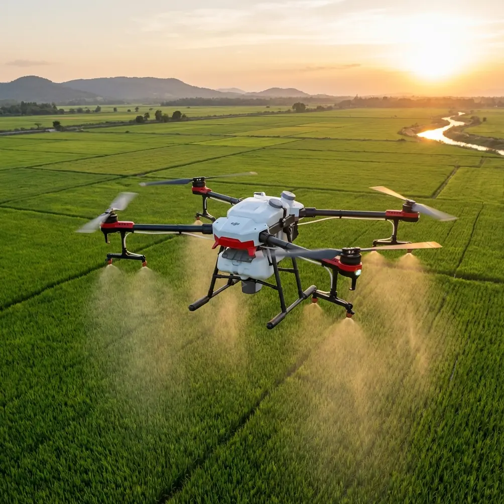
Agras T50 in Complex Terrain: How to Capture Fields Accurately Without Creating New Risk
META: A practical expert guide to using Agras T50 in complex terrain, with lessons on legal compliance, calibration discipline, drift control, RTK accuracy, and why precision workflows matter in real field conditions.
Complex terrain exposes every weakness in an agricultural drone workflow.
Terraced slopes, fragmented plots, tree lines, irrigation edges, and uneven elevation all punish shortcuts. On flat ground, a poor setup may still produce acceptable results. In broken terrain, the same mistakes show up immediately as missed coverage, uneven application, spray drift, unstable altitude behavior, and avoidable compliance problems. That is exactly why the Agras T50 deserves to be discussed not as a generic “large ag drone,” but as a platform whose value depends on disciplined operation.
Two seemingly unrelated reference points make this clear.
One is a recent enforcement case from Yongxiu County, where local public security authorities handled the county’s first drone case involving illegal or non-compliant flight activity. The other is a technical calibration document explaining compass interference compensation, including the practical benchmark that a second Z-axis compensation value often falls above 300 and below 400, while values above 400 warrant recalibration. On the surface, one is about regulation and the other about sensor setup. In field reality, they are connected. Complex-terrain operations reward operators who treat legality and calibration as part of the same system.
That is where the Agras T50 can separate itself from weaker workflows. The airframe may be advanced, but advanced hardware is not what saves an operation on a hillside plot. Process does.
Why complex terrain is harder than most operators admit
When people think about difficult agricultural flying, they often focus on obstacle avoidance or slope following. Those matter, but they are only part of the challenge.
Complex terrain changes three things at once:
- The drone’s relationship to the crop canopy
- The stability of the spray pattern across the swath
- The pilot’s margin for legal and operational error
In flat fields, swath width can remain relatively predictable because the aircraft-to-target distance is easier to maintain. In rolling or stepped terrain, every contour shift changes nozzle height, droplet behavior, and drift exposure. That affects deposition quality directly. If your nozzle calibration is slightly off, rough terrain magnifies the error. If your RTK fix rate is inconsistent, line spacing drifts. If your compass is being influenced by power lines, ESCs, or motor current, route fidelity can degrade when the aircraft most needs stable positional confidence.
The Agras T50 is attractive here because it is built for serious agricultural workflows rather than light demonstration missions. But that only translates into better field capture when operators understand the chain from sensing to path execution to application consistency.
Start with the issue most people skip: legal airspace discipline
The Yongxiu case is a useful warning, especially for agricultural readers who assume farm operations sit outside enforcement focus. They do not. The case shows that local authorities are willing to investigate and formally process unlawful or non-compliant drone flights. That matters for Agras T50 operators because field work often happens far from urban centers, which can create false confidence.
In complex terrain, pilots are already managing elevation changes, obstacle margins, and application quality. Add rushed scheduling during narrow weather windows, and it becomes easy to cut corners on approvals, flight-area checks, or procedural compliance.
That is a mistake.
Operationally, the significance is simple: a drone mission that is agronomically successful can still be operationally unacceptable if it violates local management rules. For a farm service provider, that means more than a paperwork problem. It can interrupt the season, damage client trust, and reduce the usable deployment window for the aircraft. The bigger and more capable the platform, the less room there is for casual operating habits.
For Agras T50 work, especially in complex terrain near villages, roads, reservoirs, or utility corridors, pre-flight compliance should be treated like battery verification: not optional, not delegated loosely, and never assumed.
Calibration is not a technical footnote. It is yield protection.
The calibration reference is even more relevant than it first appears.
The PIX compass document explains that magnetic interference compensation may show a second Z-axis value above 300 and below 400 and still be considered normal, while readings above 400 should trigger recalibration. It also describes the practical setup discipline around interference compensation: enable the current meter, secure the aircraft so it cannot move, keep throttle at zero, connect the flight controller to a computer, and run the appropriate compass motor compensation procedure.
Why does that matter to an Agras T50 operator capturing fields on difficult topography?
Because complex terrain increases the cost of directional error.
A compass problem on an open rectangular field may show up as slight route inconsistency. On terraced edges or narrow strip fields, it can create overlap on one pass and under-application on the next. In spraying, that means chemical waste on one side and weak protection on the other. In orchard-adjacent or water-adjacent plots, it also raises the possibility of off-target deposition. If there is any single lesson from the calibration document, it is this: electromagnetic interference is not abstract. It becomes visible in the field as poorer path integrity.
The document also notes that interference is often linked to motors, ESCs, and power wiring, and that magnetic disturbance tracks current changes in a roughly linear way. That is operationally significant because agricultural drones work under sustained load. A heavy aircraft running hard through repeated application sorties does not face the same magnetic environment as a small hobby platform floating in a park. High-current agricultural work exposes any weakness in the sensor setup.
This is one area where disciplined operators get more from the Agras T50 than less experienced crews get from competing platforms. The edge is not just the aircraft. The edge is whether the team verifies the aircraft’s navigation health before expecting centimeter-level results in the field.
A practical Agras T50 workflow for complex terrain capture
If the mission is to capture and treat fields accurately in broken terrain, the workflow should look like this.
1. Validate the mission area before the aircraft ever leaves the truck
Do not begin with route drawing. Begin with legality and geography.
Check whether the field sits near any restricted or sensitive flight zone. The Yongxiu enforcement case is enough to remind us that “rural” does not mean “ignored.” Confirm your operating permissions and local flight constraints first. Then inspect the terrain with the application objective in mind: steep grade transitions, utility lines, tree boundaries, irrigation structures, and neighboring plots that could be affected by drift.
This first step is where professional operators protect both compliance and crop results.
2. Confirm positioning integrity, not just signal presence
Many crews see satellites and move on. That is not enough in complex terrain. What matters is stable positioning quality and a reliable RTK fix rate if the workflow depends on precision track spacing.
Centimeter precision sounds like a marketing term until you fly a narrow hillside block where repeated passes must align tightly. There, even modest route drift can create visible skips or over-application. The Agras T50 is at its best when route fidelity supports repeatable canopy targeting, especially where swath planning leaves little margin.
When comparing against lighter or less agriculture-specialized platforms, this is one of the T50’s strongest practical advantages: it is built for repeat work where precision actually has financial consequences.
3. Treat compass health and interference compensation as mandatory
This is where the PIX reference becomes highly actionable.
If your calibration outputs suggest values climbing beyond the normal compensation band described in the document, especially above 400, do not normalize it. Recalibrate. Do it slowly and correctly. The source specifically warns against rushing the process. That detail matters because hurried calibration often creates a false sense of readiness. In rough terrain, that false confidence is costly.
Also pay attention to the source of interference. Power lines, ESCs, and motors are not theoretical concerns. They are common realities in agricultural systems. If a field is bounded by infrastructure or the aircraft has a single internal compass exposed to strong onboard interference conditions, your setup discipline becomes central to safe and accurate execution.
4. Build the route around terrain, not around the field boundary alone
Complex terrain capture is not just a mapping problem. It is an application geometry problem.
The goal is to preserve effective swath width and application consistency despite changing elevation and boundary shape. That usually means planning for more conservative lane behavior near steep transitions, field corners, orchard edges, and obstacle-rich sectors. If your route logic assumes the field behaves like a flat polygon, the spray pattern will expose the error.
With the Agras T50, the right question is not “How much area can I finish in one session?” The right question is “How much of this terrain can I treat without compromising deposition quality?” That shift in thinking is where professional efficiency actually comes from.
5. Recheck nozzle calibration before difficult blocks
Nozzle calibration errors are easy to hide in easy fields and hard to hide in complex ones.
Uneven flow or inconsistent atomization contributes directly to spray drift and irregular coverage. On sloped terrain, changing relative height between nozzle and target can already challenge droplet placement. Poor calibration adds another layer of instability. If the mission involves variable canopy height or terrain breaks, nozzle verification is not busywork. It is the difference between uniform treatment and visible inconsistency after the pass.
6. Watch drift risk as a terrain problem, not just a weather problem
Spray drift is often discussed only in terms of wind speed. Terrain complicates that. Slope faces, tree channels, retaining edges, and temperature-driven local airflow can move droplets in ways that broad weather readings do not fully describe.
This is one reason the Agras T50 tends to outperform generic drone workflows in hard agricultural environments. A platform designed for real crop application is only useful if the operator reads the micro-environment correctly. When a competitor’s system looks adequate on paper but falls apart in uneven fields, it is often because the mission was treated like route automation rather than fluid delivery management.
What the Tello education example quietly teaches larger ag operators
The educational Tello reference may seem unrelated to Agras T50 farming, but it contains an interesting operational lesson.
In that material, two drones react together when a TOF distance sensor detects a hand within 60 centimeters, triggering synchronized display and movement behavior. The concept is simple: one sensor event can drive coordinated system response. For agricultural operations, the lesson is not about choreography. It is about responsive sensing.
In complex terrain, proximity awareness and trigger-based behavior are not luxury features. They are part of what separates a drone that merely follows a route from a drone that remains situationally competent while working close to terrain, crop structures, and edge conditions. Even though the Tello example is educational and small-scale, the underlying principle carries upward: sensing only matters when it changes behavior fast enough to protect the mission.
That is also a useful way to think about the Agras T50 versus less specialized alternatives. The strongest agricultural platforms are not just bigger. They are better at turning sensor awareness into reliable action under workload.
Where Agras T50 really excels against weaker alternatives
The easiest way to misunderstand the T50 is to reduce it to payload or output.
Its real advantage in complex terrain is that it supports a precision-first workflow at scale. That means:
- holding route quality where field geometry is messy,
- maintaining useful swath discipline where elevation changes challenge canopy distance,
- giving professional operators a better foundation for controlling drift,
- and supporting repeatable, compliant field service rather than one-off flights.
Many competitors can look similar in straightforward fields. The gap widens when the mission combines terrain variation, operational urgency, and narrow agronomic tolerance. That is when calibration discipline, RTK consistency, and route fidelity stop being technical jargon and start becoming crop outcomes.
If you are evaluating whether a T50 setup fits your fields, especially if you work fragmented plots or hilly acreage, it helps to discuss the workflow rather than just the hardware. A direct WhatsApp conversation can be useful for that: message a field application specialist here.
The real standard for “capturing” complex fields
For the Agras T50, capturing a field in complex terrain should mean more than completing a route log.
It should mean:
- the mission was lawful,
- the compass and navigation stack were trustworthy,
- the RTK-supported track spacing held where it mattered,
- the nozzle setup matched the agronomic objective,
- drift was controlled in relation to terrain,
- and the final application was even enough to justify the flight.
That is the standard professional agriculture is moving toward.
The references behind this article point in the same direction, even though they come from very different contexts. One reminds us that authorities are watching unlawful drone activity. Another reminds us that interference compensation values and careful recalibration are not trivial details. Together they describe the modern reality of agricultural drone work: precision is not only about coverage efficiency. It is about disciplined operation from authorization to final pass.
For operators working difficult ground, that is where the Agras T50 earns its place.
Ready for your own Agras T50? Contact our team for expert consultation.