Agras T50 Capturing Tips for Urban Field Work When Light
Agras T50 Capturing Tips for Urban Field Work When Light, Edges, and Weather Refuse to Cooperate
META: Practical Agras T50 field capture advice for urban agriculture workflows, with expert insight on edge definition, changing light, spray drift awareness, RTK stability, and how mid-flight weather shifts affect usable field imagery.
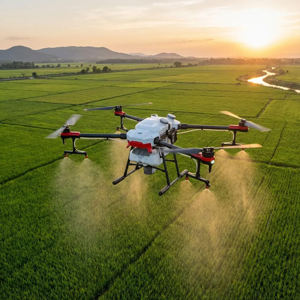
Urban field work looks simple from the sidewalk. A few rectangular plots. Narrow access lanes. Buildings on one side, trees on the other. Then you put an Agras T50 in the air and realize the real challenge is not just flying the mission. It is getting usable visual information when the scene is full of edge traps, mixed lighting, and shifting wind.
That matters more than most operators admit.
The Agras T50 is usually discussed for output: coverage, tank capacity, swath efficiency, application consistency. Those are legitimate priorities. But in dense agricultural pockets near roads, greenhouses, walls, and residential structures, the quality of what you capture before, during, and after the job often determines whether the operation stays precise. If your visual read on crop boundaries, canopy shape, and obstacle edges is weak, every downstream decision gets softer too. Spray drift risk assessment suffers. Nozzle calibration checks become less grounded in field reality. Even route adjustments can turn reactive instead of planned.
The easiest way to understand this is through a camera principle that seems unrelated at first: portrait mode on a phone.
A recent Chinese photography tip sheet highlighted something every drone operator should remember. Portrait-style background separation works best when the camera keeps an appropriate distance from the subject. In good light, the separation looks natural and the subject stands out clearly. But when there are lots of stray hairs against the background, edge recognition often breaks down. In low light, subject boundaries become soft and the effect degrades quickly. A wide aperture helps for close-up emphasis, but it can also exaggerate what gets isolated and what gets lost.
That is a phone lesson. It is also an Agras T50 lesson.
The urban field problem: edges lie first
In urban agriculture, edges are everything. Not just field borders, but crop-to-soil transitions, trellis lines, utility poles, fencing, irrigation hardware, parked vehicles, greenhouse plastic, shade cloth, and rows of mixed-height vegetation. If your visual interpretation of those edges is off by a little, your operational buffer can be off by a lot.
Phone portrait mode struggles when loose hair blends into the background. A T50 operator faces the aerial equivalent when thin leaves, tassels, vine growth, or wind-moved canopy texture sit in front of visually noisy surroundings like concrete, rooftops, reflective panels, or dense urban clutter. The significance is practical: what looks like a clean boundary from one angle may not be a stable edge at all once the aircraft changes altitude or the wind shifts.
That is why “capturing fields” with the T50 should never mean simply collecting footage or stills. It means capturing interpretable field conditions under constraints. The goal is operational clarity.
Why distance still matters, even on an agricultural platform
The phone reference makes one point especially well: distance affects how natural the separation looks.
Translate that into T50 use, and the takeaway is straightforward. If you try to assess a field edge, crop density change, or obstacle line from the wrong standoff distance, the scene can flatten. Too close, and you get exaggerated foreground detail without enough spatial context. Too far, and subtle transitions disappear into a single texture block.
For urban fields, the best capture pass is often not the first one. It is the second pass after you have seen where visual separation fails.
On the T50, this matters for three reasons:
Spray drift planning
If the field edge sits next to roads, homes, walls, or water-sensitive surfaces, you need a confident read on the true treatment boundary before application. A poor visual estimate can lead to conservative under-coverage or risky edge behavior. The drone may be capable of accurate delivery, but your setup quality depends on how well you identified the real edge in the first place.Swath width decisions
Swath width is not just a performance variable. In constrained areas, it is a visual confidence variable too. A wider pass may be efficient in open acreage. In urban plots with irregular boundaries, reducing width can help preserve accuracy around complex margins because you are not forcing the system to treat messy edges like open geometry.Nozzle calibration verification
Calibration is often discussed as a bench or prep task, but field visuals influence whether the chosen setup still makes sense on site. If canopy density changes abruptly near built structures or shaded areas, your intended application pattern may need adjustment. Better visual capture helps you confirm whether your planned output matches what the field actually presents.
Good light is not a luxury
The source material also stresses that portrait mode performs better in strong light, while low-light scenes cause subject edges to blur. That is not a trivial consumer-camera observation. It is a field rule.
Urban plots often create uneven light even during otherwise favorable hours. Building shadows move across rows. Reflective glass brightens one side of the scene. Tree cover creates alternating patches of contrast. Under those conditions, the visual cues you rely on for crop edge definition can become inconsistent within minutes.
Here is what this means on an Agras T50 job:
- A field that looked clean and readable on takeoff can become visually compressed as shadow reaches the crop.
- Darker zones can hide elevation differences, lodged plants, or irrigation lines.
- Edge clutter becomes harder to distinguish when contrast drops.
- Mid-mission review decisions get weaker if your capture was made after the light turned flat.
This is why experienced operators build visual checks into the workflow before committing to the main operation. Not because the aircraft lacks capability, but because human interpretation degrades before the platform does.
A mid-flight weather change is where discipline shows
One afternoon mission in an urban fringe plot makes the point.
The site was a compact field bordered by a wall on one side and low buildings on the other. Conditions at launch were decent: stable visibility, enough light to define the rows, manageable wind. Then the weather shifted mid-flight. A light overcast thickened faster than expected, and the breeze changed direction just enough to raise new questions about spray drift near the wall line.
This is where many operators make a mistake. They focus only on whether the drone can keep flying.
The better question is whether the capture quality and application assumptions are still valid.
The T50 handled the flight environment without drama. A robust agricultural platform is built for demanding outdoor work, and operators value features like IPX6K-style durability because agriculture does not wait for pristine conditions. Dust, moisture, residue, and changing weather are ordinary, not exceptional. But environmental resilience is only part of the story. The operational win came from reassessing the mission after the weather changed, not from pushing through on autopilot.
As the light flattened, crop boundaries against the darker soil became less distinct. Along the wall edge, the canopy line that looked obvious earlier became visually softer. At the same time, the wind change increased concern around spray drift. That combination mattered. The mission profile was adjusted, the edge treatment strategy tightened, and the operator prioritized zones with stronger visual confidence first.
That is what a disciplined T50 workflow looks like in practice: not blind faith in automation, but a constant link between aircraft capability, visual truth, and agronomic judgment.
RTK fix rate and centimeter precision only matter if the scene is interpreted correctly
People love to talk about centimeter precision, and for good reason. With a strong RTK fix rate, the T50 can support repeatable, high-accuracy route execution in structured field operations. In urban environments, that positional confidence becomes even more valuable because access is tight and margins matter.
But precise positioning does not automatically solve visual ambiguity.
If your operator misreads a crop edge because low light softened the boundary, or because thin vegetation visually merged into a cluttered background, even perfect route repeatability can reproduce the wrong assumption with admirable consistency. That is the uncomfortable truth.
So yes, RTK matters. A high fix rate helps maintain stable spatial confidence near obstacles, irregular plots, and narrow treatment corridors. It supports route integrity and can improve how confidently you line up passes in constrained spaces. But it must be paired with careful scene reading. Precision is not a substitute for interpretation.
The “stray hair” problem in field capture
The phone article’s warning about stray hair causing edge recognition errors is a surprisingly strong analogy for urban agriculture.
In aerial terms, “stray hair” can be:
- tassels or fine stems breaking above the canopy
- weeds scattered along a field edge
- netting, wires, or trellis strands
- plastic sheeting edges moving in the wind
- vine growth crossing into non-crop space
These details can fool the eye and distort perceived boundaries. Operational significance is obvious. If you treat every thin protrusion as a true crop limit, your effective field shape expands. If you ignore them entirely, you may trim coverage too aggressively. The answer is not to chase every visual fragment. It is to identify the stable edge structure underneath the noise.
That takes repeat observation from more than one angle, especially when weather or light has changed.
Where multispectral thinking enters the conversation
Not every T50 workflow will involve multispectral data, but the concept is still useful here. Visual capture in urban fields often reaches its limit when contrast is weak or the scene is too cluttered. That is where operators with access to additional sensing workflows gain an advantage. Even if the T50 itself is the application platform, integrating a broader field assessment mindset can help separate actual crop condition from visual confusion.
The point is not to force a mapping workflow into every spraying job. The point is to understand that visible imagery alone can be deceptive when buildings, shade, and reflective surfaces fragment the scene.
A practical capture framework for T50 urban field operators
If your assignment is “capture the field” before treatment, do it with operational intent:
1. Start with the edges
Do not begin in the center of the plot. Urban risk lives at the margins. Inspect walls, roadsides, greenhouse perimeters, drainage lines, and any crop boundary next to sensitive surfaces.
2. Use light deliberately
The source reference is clear: better light gives cleaner subject separation. For the T50 operator, that means planning capture when edge contrast is strongest, not simply when the schedule is open.
3. Recheck after weather changes
If cloud cover thickens or wind direction shifts mid-flight, revisit your assumptions. The drone may still be stable. Your visual confidence may not be.
4. Match swath width to boundary complexity
A broad swath can look efficient on paper. In urban plots, a narrower, more controlled pattern often reflects the actual geometry better.
5. Tie visuals back to nozzle calibration
Calibration should reflect field reality, not just theoretical output. If canopy density or edge structure varies sharply, review whether your planned setup still fits.
6. Respect RTK, but do not worship it
Centimeter precision is powerful. It does not excuse a bad read of the field.
The real lesson
The most useful insight from the reference material is simple: image separation depends on distance, edge cleanliness, and light quality. That may sound like smartphone advice, but in urban agriculture it becomes mission logic.
The Agras T50 is strong where it needs to be strong: repeatable, field-ready, durable, and capable in demanding agricultural workflows. Yet in compact urban fields, the difference between a routine operation and a sharp one often comes down to how well the operator reads visual ambiguity before acting on it.
If you want better T50 field capture, stop thinking only about the aircraft. Think about subject isolation. Think about false edges. Think about what happens when the light drops and the wind moves halfway through the job.
That is where operational quality is decided.
If you are comparing urban field setups or want a second opinion on how to configure a tighter T50 workflow, you can message Marcus directly here and discuss the field conditions before the next mission.
Ready for your own Agras T50? Contact our team for expert consultation.