Agras T50 Technical Review for Coastal High
Agras T50 Technical Review for Coastal High-Altitude Operations
META: Expert Agras T50 best practices for coastal high-altitude flying, covering spray drift control, nozzle calibration, RTK fix reliability, IPX6K cleaning, and safer pre-flight workflow.
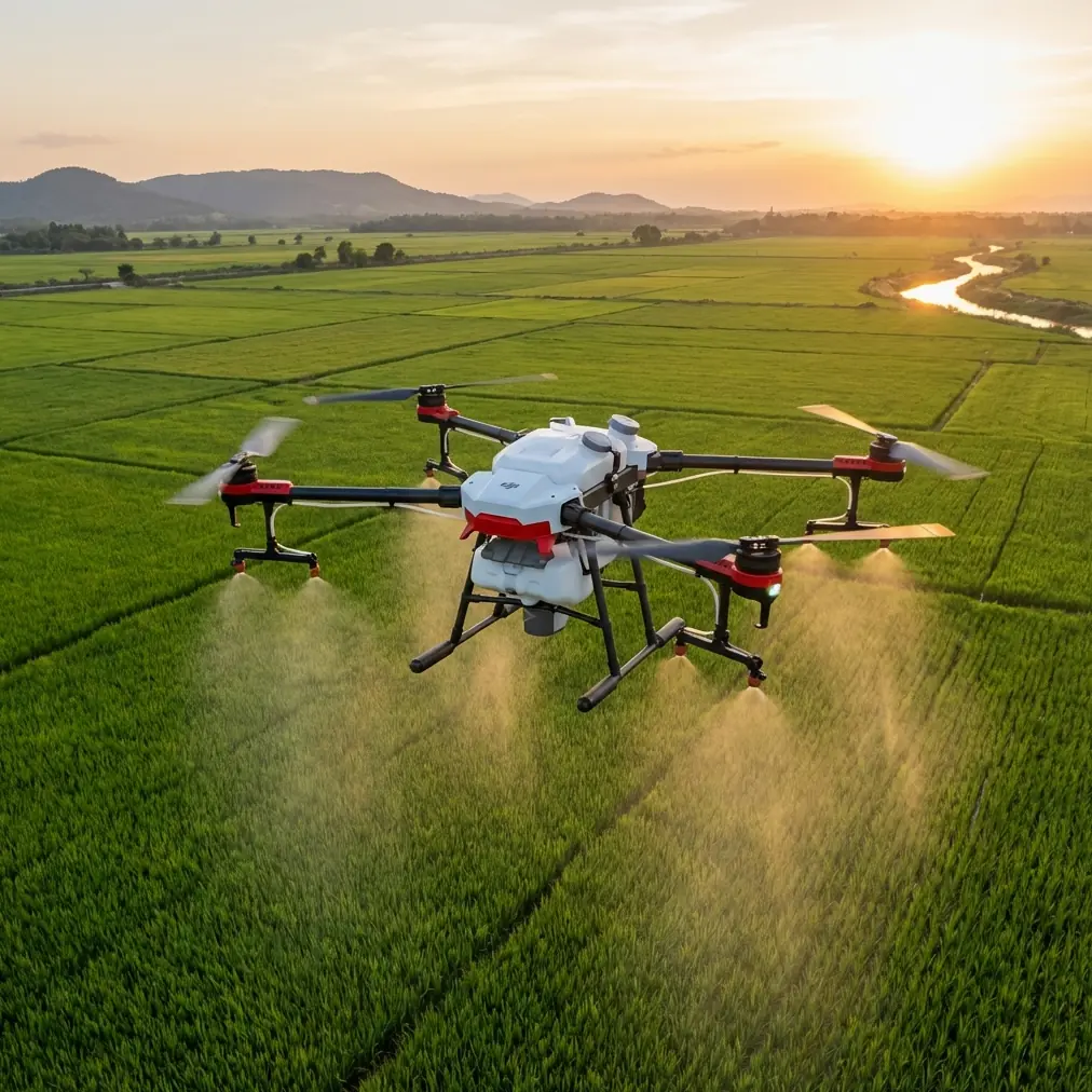
The DJI Agras T50 is usually discussed in the language of acreage, tank volume, and throughput. That makes sense in broad-acre agriculture. But those talking points miss a harder question: how does the platform behave when the mission pushes beyond flat inland fields and into coastal, elevated terrain where wind shear, salt residue, and positioning reliability all start working against you?
That is the more interesting test.
For operators tasked with work along coastlines at higher elevations, the Agras T50 is not simply a bigger spraying drone. It becomes a systems-management problem. Spray drift becomes less forgiving. Nozzle calibration matters more than it does in sheltered plots. The RTK fix rate stops being an abstract specification and turns into a practical limit on whether your passes remain consistent enough to avoid skips and overlaps. Even the machine’s cleaning routine, especially before flight, becomes part of flight safety rather than simple housekeeping.
From an academic and field-operations perspective, that is where the T50 deserves a closer look.
Why coastal high-altitude work changes the equation
A drone that performs neatly in a protected inland environment can behave very differently above a coastline escarpment, bluff, or terraced agricultural edge. Airflow is less uniform. Wind can move laterally off the water and then break upward when it meets terrain. At the same time, salt-laden moisture tends to settle on exposed equipment. Those two factors alone change how an Agras T50 should be prepared and flown.
The first operational consequence is spray drift. In coastal air, especially where sea breeze interacts with elevation changes, droplets do not just move downwind in a simple horizontal path. They can lift, curl, and disperse unevenly. That matters because the effectiveness of an application is tied not only to coverage, but to where the material does not go. A wide swath width can be productive in stable conditions, yet on a ridge or coastal shelf it may need to be reduced to preserve deposition accuracy.
The second consequence is positioning discipline. High-altitude coastal routes can produce intermittent masking from terrain or surrounding infrastructure. In those moments, the RTK fix rate becomes one of the most operationally significant metrics in the entire mission. Centimeter precision is not a luxury here. It governs line spacing, repeatability, and confidence when the aircraft returns for another pass over irregular edges. If the fix is unstable, a nominally efficient plan can turn into a patchy one very quickly.
The T50’s real advantage: stability as a workflow, not a spec sheet
The Agras T50’s appeal in demanding environments is less about one standout number and more about how its capabilities interact. Large-platform spraying drones are often judged by how much area they can cover in one session. That has value, but coastal high-altitude operations reward control more than raw pace.
This is where the T50’s professional architecture matters. With RTK-enabled centimeter precision, the aircraft is well suited for repeatable path execution in places where field geometry is awkward and borders are sensitive. On paper, that sounds routine. In practice, it is the difference between a clean edge pass and a recurring under- or over-treated strip that compounds across a slope.
There is also a tendency to discuss multispectral tools as separate from spraying missions, but that separation is often artificial. In coastal zones, multispectral scouting can be especially useful before application planning because plant stress patterns may follow drainage, salt exposure, or wind exposure rather than neat field blocks. When that insight is paired with a T50 mission, the spray plan becomes more selective. The drone’s role is no longer simple blanket coverage; it becomes a delivery platform for a more disciplined treatment map.
That distinction matters operationally. In difficult environments, the best mission is rarely the broadest one. It is the one with the fewest unnecessary passes.
Pre-flight cleaning is a safety step, not cosmetic maintenance
One point is often underestimated by otherwise competent operators: pre-flight cleaning. Along coastlines, this should be treated as a front-line safety protocol.
The T50 is designed for demanding outdoor work, and an IPX6K protection level gives the platform a meaningful degree of resistance against heavy water exposure during cleaning. That is a practical advantage, not a decorative label. It allows operators to wash away residue that would otherwise accumulate around spray components, frame surfaces, landing gear, connectors, and sensor-adjacent areas. In coastal use, the residue is not only chemical. Salt film and fine particulate contamination can build up faster than many crews expect.
Why does that matter before takeoff?
Because residue changes how systems behave. Dried deposits around nozzles can alter spray pattern symmetry. Film on relevant sensing surfaces can reduce confidence in automated behavior. Salt accumulation around mechanical interfaces can gradually increase wear or interfere with normal motion. A rushed crew may think of cleaning as an end-of-day task. In a coastal high-altitude scenario, a short pre-flight clean and inspection is often the smarter move.
My preferred workflow is simple. First, visually inspect all spray outlets and confirm there is no dried material that could distort atomization. Second, check that intake and vent areas are free from salt crusting or particulate buildup. Third, wipe and verify any exposed surfaces associated with sensing and positioning support. Only after that should nozzle calibration and route confirmation begin.
That sequence sounds basic. It is not. It directly supports safer feature performance.
Nozzle calibration is where coastal missions are won or lost
Nozzle calibration is frequently treated as a checkbox. On the T50, especially in exposed environments, it should be treated as a performance control point.
A small deviation in flow uniformity may be tolerable in forgiving conditions. Over a windy coastline at elevation, it becomes magnified. If one side of the spray pattern is under-delivering while the aircraft is also fighting crosswind drift, the resulting distribution error can become substantial. The operator then faces a familiar but costly problem: rework, uneven efficacy, or both.
This is why calibration should not stop at “the system says ready.” Operators should verify practical output consistency and reevaluate target droplet behavior against actual conditions. Swath width deserves particular attention here. A broad swath can look efficient on a planning screen, but if the local airflow is unstable, narrowing the effective swath may produce better real-world coverage and less drift beyond the intended area.
For coastal high-altitude missions, I recommend thinking of nozzle calibration as part of environmental tuning. The question is not simply whether the nozzles are functioning. The question is whether the entire delivery pattern still makes sense for the day’s wind profile, humidity, and terrain-induced turbulence.
That is a stricter standard, and it should be.
RTK fix rate is the hidden metric that shapes mission quality
Many operators focus on flight stability in visual terms: does the aircraft look steady, and is the route progressing as planned? Those cues are useful, but they can conceal a deeper positioning problem. In the T50’s operating context, the RTK fix rate is one of the strongest indicators of mission integrity.
A reliable RTK fix supports centimeter precision, which matters profoundly when running repeated lines over coastal boundaries, narrow access areas, or irregular agricultural contours. If the aircraft loses consistent high-quality positioning, tiny path deviations accumulate. On a broad inland field that may be recoverable. Along a coastline, where one edge may border sensitive vegetation, water, or steep terrain, the tolerance is tighter.
Operationally, that means crews should monitor not just whether RTK is active, but how robustly it is holding throughout the mission window. If the fix quality is marginal before launch, it is better to delay or adjust the plan than to trust that the route will somehow self-correct in the air.
This is particularly true in elevated coastal locations where signal geometry can be complicated by cliffs, ridgelines, built structures, or temporary interference. Centimeter precision only helps when it is consistently available. The T50 can leverage that precision very effectively, but the mission design has to respect the limits of the environment.
Spray drift control is more than slowing down
The most common reaction to drift risk is to reduce speed. Sometimes that helps. Often it is incomplete.
On the Agras T50, meaningful drift control in coastal high-altitude operations comes from a combination of decisions: confirming nozzle calibration, adjusting swath width, selecting the right mission window, maintaining a strong RTK fix, and recognizing when terrain creates vertical airflow that defeats an otherwise reasonable plan.
This is where experienced operators distinguish themselves. They do not assume the same route that worked yesterday at 8 a.m. will work again at noon. Coastal wind behavior can change quickly. A route segment near a cliff edge may require a more conservative approach than the interior of the same property. Spray drift management therefore becomes a spatial problem, not just a weather problem.
If a team is trying to standardize this kind of work, I suggest building a field briefing around three variables before every launch: expected drift direction, acceptable swath width for the day, and minimum RTK confidence for mission start. Those three items do more to improve consistency than generic reminders ever will. If your crew needs a practical checklist for that discussion, a quick field coordination note shared through our Agras operations desk can keep setup disciplined without slowing the launch sequence.
Where multispectral planning fits into a T50 coastal workflow
The Agras T50 is not itself a multispectral survey platform in the way a dedicated mapping aircraft might be, but coastal operations benefit when spray missions are informed by multispectral data collected beforehand. That distinction matters because exposed coastal crops often show stress patterns that are spatially complex. Salt exposure, drainage, and wind loading can create treatment zones that look uneven even within a small block.
When an operator uses multispectral information to define those zones, the T50’s precision becomes much more valuable. Instead of flying a broad uniform treatment across a variable site, the aircraft can execute a plan that better matches actual crop condition. In difficult terrain, fewer unnecessary passes means lower exposure to drift, lower cumulative risk, and more predictable use of the weather window.
That is the kind of integration professional users should be aiming for. Not maximum airtime. Maximum decision quality.
A realistic technical verdict
The Agras T50 is a strong platform for demanding application work, but coastal high-altitude missions expose whether the crew understands system interaction. This is not a drone that succeeds purely because it carries more or flies farther. It succeeds when operators respect the relationship between spray physics, terrain, and positioning quality.
Two details stand out as operationally decisive.
First, the platform’s RTK-based centimeter precision is genuinely valuable in irregular coastal environments, where line repeatability and boundary control are more difficult than standard field work. The significance is practical: better path fidelity means fewer missed strips and fewer overlaps, especially when the route hugs edges or contours.
Second, the IPX6K-rated design supports aggressive cleaning practices that are especially relevant near saltwater. That is not just about durability. It enables a pre-flight cleaning routine that protects spray consistency and helps safety-related systems perform as intended by reducing residue and contamination before launch.
Add disciplined nozzle calibration, conservative swath width decisions when needed, and a serious attitude toward drift, and the T50 becomes much more than a high-capacity agricultural drone. It becomes a precise aerial application tool capable of working in one of the more demanding environmental niches an operator will face.
For coastal high-altitude work, that is the standard worth using.
Ready for your own Agras T50? Contact our team for expert consultation.